Export map, cross section profiles, and charts from RockPlot2D to Google Earth. Output can be draped on the ground surface or floated at a defined elevation.
RockPlot2D Maps
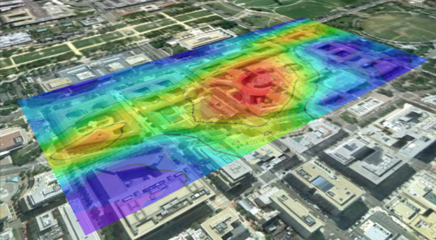
Save a RockWorks-generated 2D map (contours, points, etc.) to Google Earth. Adjust transparency to view features below the map.

RockPlot2D Profiles
Display your RockWorks-generated 2D profiles (stratigraphy, lithology, contoured panels, etc.) in Google Earth, georeferenced using the section’s endpoints.

RockPlot2D Diagrams
Georeference your RockWorks-generated 2D graphs and charts for display in Google Earth.

Export scenes from RockPlot3D to Google Earth. Adjust vertical placement, vertical exaggeration, and lighting.


Use the programs in the RockWorks EarthApps menu to read spatial data from the datasheet and generate Google Earth KML/KMZ files which illustrate the map locations, display floating or draped images, run flyover tours, and more.
EarthApps Point Maps
Quickly locate a single point in Google™ Earth, and create maps which illustrate X,Y locations with icon symbols, circles, cones, cylinders, strike and dip symbols

EarthApps Line Maps
Read line and polyline coordinates, and display these in Google Earth as simple lines, tubes, pipelines, and parabolas.

EarthApps Polygon Maps
Create a single polygon map from a single list of vertex coordinates or multiple-polygon map from multiple lists of polygon coordinates.

EarthApps Image Maps
Create a variety of Google Earth displays with raster images – draped images, floating images, vertical images, and image legends.

EarthApps Flyovers
Read XY locations from the RockWorks datasheet or the clipboard, and create flyover tours in Google Earth.

EarthApps Cell Maps
Create a grid representing your samples and display the cells as color-coded and/or extruded bars.

EarthApps Survey Maps
Read survey measurements and plot points or polygons in Google Earth

EarthApps Extraction Tools
Read location data that has been copied or saved in Google Earth, and list the coordinates in the EarthApps Datasheet. This provides an easy method for capturing coordinates from shapes drawn in Google Earth
