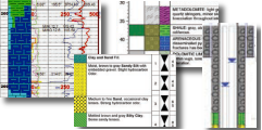
 |
|
 |
 |
100+ Hatch Library |
 |
AutoCAD® Hatch patterns - more than 350 hatch patterns
for AutoCAD, AutoCAD LT and Autodesk® ADT |
$79.00
|
|
 |
 |
 |
 |
AqQA |
 |
| Software for water analyses: unit conversion, anion-cation balance, sample mixing, detect exceedances, calculate basic fluid properties (TDS, hardness, conductivity etc.), water chemistry diagrams (Piper, Stiff, Ternary, Durov and more). |
$249.00
|
|
 |
 |
 |
 |
AquaChem |
 |
| The most complete system for water quality data analysis, plotting, reporting and modeling. |
$1,390.00
|
|
 |
 |
 |
 |
ArcIMS |
 |
| Publish maps, data and metadata on the web |
|
|
 |
 |
 |
 |
ArcPad 8 |
 |
| Mobile GIS software for field mapping applications |
|
|
 |
 |
 |
 |
ArcView 9 |
 |
| The world's most popular desktop mapping and GIS software |
|
|
 |
 |
 |
 |
ArcView GIS 3.x |
 |
| Desktop mapping and GIS software with spatial analysis tools |
|
|
 |
 |
 |
 |
Baro-Diver |
 |
| A groundwater monitoring instrument used specifically to record barometric pressure |
|
|
 |
 |
 |
 |
CAD2Shape |
 |
A dwg and dxf converter that converts DWG/DXF files to ESRI SHP (shapefile).
|
$179.00
|
|
 |
 |
 |
 |
Cera-Diver |
 |
| An accurate groundwater data recording instrument for caustic environmental conditions |
|
|
 |
 |
 |
 |
ChemStat |
 |
| Environmental Statistical Analysis Software Solution for Windows |
$990.00
|
|
 |
 |
 |
 |
CTD-Diver |
 |
| CTD-Diver is an accurate, multi-parameter groundwater datalogger instrument. |
|
|
 |
 |
 |
 |
DeltaGraph |
  |
| Graphs, plots and charts that stand the test of time- available for Windows and MacIntosh |
$295.00
|
|
 |
 |
 |
 |
Didger |
 |
| All the advanced digitizing features you need in a low-cost, unbelievably versatile program |
$369.00
|
|
 |
 |
 |
 |
Diver VisiONE |
 |
| Intuitive and practical, Diver-VisiONE is a groundwater software application designed for public water agencies, environmental consultants, and industries to effectively manage their groundwater monitoring and reporting requirements. |
$2,495.00
|
|
 |
 |
 |
 |
Encom Discover |
 |
| The desktop Geographical Information System (GIS) designed especially for the geosciences, providing the tools to effectively compile, visualise, analyse and map spatial geoscience data |
|
|
 |
 |
 |
 |
Encom PA |
 |
Integrate, analyze and visualize geophysics, geochemistry
and geology data from various sources. |
$3,720.00
|
|
 |
 |
 |
 |
Global Mapper |
 |
| View, merge, import and export a large variety of vector, raster, and elevation data sets |
$299.00
|
|
 |
 |
 |
 |
Grapher |
 |
| Efficient and powerful graphing software for your most complex graphing needs |
$300.00
|
|
 |
 |
 |
 |
GS+ |
 |
| Geostatistics software for the environmental and geosciences |
$649.00
|
|
 |
 |
 |
 |
GW Contour |
 |
| A Powerful Data Contouring and Visualization Program Designed Specifically for Groundwater Professionals |
$490.00
|
|
 |
 |
 |
 |
GWB Standard |
 |
| The original! Contains all the tools of GWB Essentials, and adds powerful reaction path modeling capabilities. |
$3,499.00
|
|
 |
 |
 |
 |
Hydro GeoAnalyst |
 |
An all-in-one groundwater and borehole data management and visualization solution for environmental professionals
|
$5,490.00
|
|
 |
 |
 |
 |
LogPlot |
 |
| LogPlot 7 - borehole log plotting software for the civil, environmental, mining and petroleum geoscientist |
$699.00
|
|
 |
 |
 |
 |
LP360 |
 |
| A first of its kind LIDAR extension for the ESRI™ environment |
$2,990.00
|
|
 |
 |
 |
 |
MapInfo Professional 10.0 |
 |
| MapInfo 10.0 is a powerful Microsoft® Windows®-based mapping and geographic analysis application from the experts in location intelligence. |
|
|
 |
 |
 |
 |
Micro-Diver |
 |
| Micro-Diver is a compact groundwater monitoring data logger. |
|
|
 |
 |
 |
 |
Mini-Diver |
 |
| A compact and versatile groundwater monitoring instrument |
|
|
 |
 |
 |
 |
PetraSim |
 |
| Interactive model creation for advanced flow, transport and heat transfer models. A preprocessor and postprocessor for TOUGH2, T2VOC, TMVOC, TETRAD and TOUGHREACT. |
$3,000.00
|
|
 |
 |
 |
 |
PLog |
 |
| PDA-based field data collection software- with a gINT interface |
|
|
 |
 |
 |
 |
RockWorks |
 |
| RockWorks15 is your geology toolbox- boring logs, cross-sections, fence diagrams, 3D models and much more. |
$2,499.00
|
|
 |
 |
 |
 |
RockWorks Utilities |
 |
| Contour maps, gridding tools, solid models, volumetrics, piper/stiff diagrams, stereonets, ternary diagrams and more! |
$599.00
|
|
 |
 |
 |
 |
Smartimage |
 |
| Image manipulation software for ArcView® (3.1 to 3.3) and MapInfo®: image registration (georeferencing), mosaicking, clipping and more |
$299.00
|
|
 |
 |
 |
 |
Surfer |
 |
| A powerful contouring, gridding, and surface mapping package for scientists and engineers |
$659.00
|
|
 |
 |
 |
 |
Vertical Mapper |
 |
| An extension for MapInfo Professional. Vertical Mapper is the ultimate tool for geospatial data analysis. |
|
|
 |
 |
 |
 |
Visual MODFLOW + SEAWAT |
 |
| Visual MODFLOW + SEAWAT delivers powerful features for simulating 3D variable-density groundwater flow coupled with multi-species solute and heat transport |
$1,790.00
|
|
 |
 |
 |
 |
Visual MODFLOW Premium |
 |
| The industry standard for 3D groundwater flow and contaminant transport modeling with 3D visualization and parameter estimation. Also includes SAMG solver and MT3D99. |
$4,890.00
|
|
 |
 |
 |
 |
Visual MODFLOW Pro |
 |
| The industry standard for 3D groundwater flow and contaminant transport modeling with 3D visualization and parameter estimation. |
$3,490.00
|
|
 |
 |
 |
 |
WellCAD |
 |
| Comprehensive well log data management, analysis and visualization. |
$3,120.00
|
|
 |
 |
 |
 |
WhiteStar |
 |
| High quality cartographic data: PLSS, DED, DOQQ, well headers, culture data and more |
|
|
 |
 |
 |
|
 |