If you have a RockWorks license with expired maintenance contact RockWare, or visit the RockWare Customer Portal to renew your maintenance so that you can update to the new version.
If you are using RockWorks20xx and are current on maintenance, the 4-digit program name will move up to the current year "RockWorks2026" when you install the first release of each new year.
Click HERE And scroll below the image to download the Free Trial
A note about file syncing while working in Rockworks. When your projects are stored with programs like OneDrive or Dropbox, you may experience delays in saving from RockWorks or receive errors about the database being unavailable (unable to save). This is because both programs are trying to sync simultaneously. If you want to avoid this inconvenience, please pause the SYNC feature in the storage programs while working in RockWorks. Also, when using OneDrive with RockWorks, it is NOT recommended that the Documents folder be remapped to OneDrive.
(036) 03/24/26/JPR - Improvement:
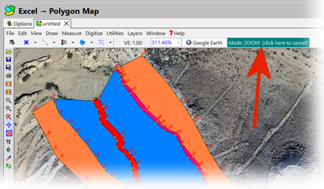
The RockPlot2D program has been modified such that the current "mode" is prominently displayed at the top of the dialog. Clicking on the mode button will automatically cancel the current mode and return control to the "Edit Mode". This replaces the former controls that were less prominently displayed within the lower-left corner of the screen.
(035) 03/24/26/PR - Bug Fix:
The point-in-triangle algorithm that is used by a wide variety of RockWorks applications no longer rarely misidentifies a point. By "rarely" we mean once in the last 20 years.
(034) 03/16/26/JCJ - Improvement:
Creating a Lithology model in RockPlot3D, the Lithology types were being saved in the file as element names. In strict XML it is not allowed to have spaces in element names. The Lithological Types and Names are now saved as attributes allowing them to have spaces.
(033) 03/17/26/JPR - Bug Fix:
Converting Coordinates in the RockPlot3D Utilities now converts the internal X, Y, Z offsets as expected.
(032) 03/16/26/JPR - Improvement:
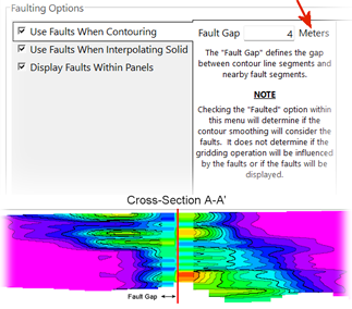
A "Fault Gap" option, that defines the gap between contour line segments and nearby fault segments, expressed in Project Units (Feet or Meters), has been added to the Faulting | Use Faults When Conntouring tab.
(031) 03/16/26/JPR - Improvement:
Key improvements have been made to the ModOps | Grid | Import | Raster program, especially related to tif imports.
Click to view this Write up from the online Knowledge Base to read about all of the improvements.
(030) 03/12/26/JCJ - New Feature:
When the mouse pointer is positioned over certain menu items (e.g., Stratigraphy Layered Model), a small abstract is displayed describing the output produced by that command. These images are now stored in a TImageCollection, where each image is maintained individually in a compressed PNG format. This change eliminates the need to load a large bitmap at startup, reducing memory usage and decreasing the overall size of the RockWorks executable.
(029) 03/06/26/JPR - Improvement:
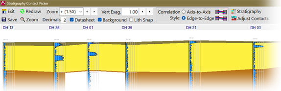
The ribbon menu as the top of the Lithology, Stratigraphy, and Hydrostratigraphy "Pickers" has been condensed to accommodate smaller monitors.
(028) 03/03/26/JPR - Improvement:
The smoothing within the Utilities | Maps | Triangulation Contours program has been improved such that the contour lines are in-synch with the color bands.
Click to view this Write up from the online Knowledge Base to learn more.
(027) 03/01/26/JPR - New Feature:
Two new capabilities have been added to the Borehole Operations | Maps | Striplog Map program:
Click to view this Write up from the online Knowledge Base to learn more.
(026) 02/22/26/JPR - Bug Fix:
The Borehole Operations | Maps | Striplogs Plan View program now includes textual information for inclined and deviated boreholes and omits all vertical boreholes.
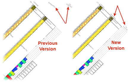
(025) 02/22/26/JPR - Bug Fix:
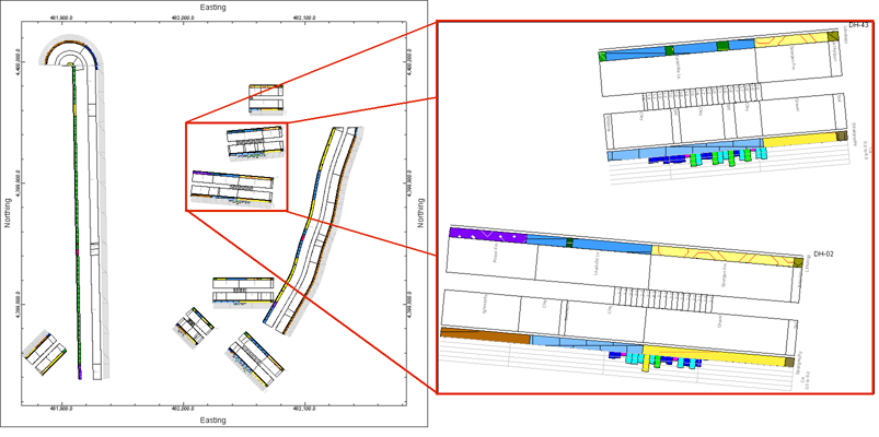
Column titles within striplogs that are projected into a 2D vertical plane are plotted directly over their respective column of data.
(024) 02/13/26/JCJ - Bug Fix:
When changing projects, RockWorks closes the previous project's windows. Sometimes this would result in a pointer or access violation error, which has been resolved.
(023) 02/08/26/JPR - Improvement:
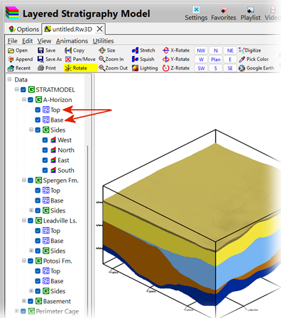
The formations within a layered stratigraphy model no longer list the "Elevation Grid" as a sub-item for the Top and Base of each unit.
(022) 02/06/26/JPR - Improvement:
A new option titled “Faulting” has been added to the upper tab bar for all programs that may involve faulting. This redesign centralizes the fault-related options into a single location rather than being distributed throughout the various sub-menus.
Click to view this Summary from the online Knowledge Base to learn more.
(021) 02/04/26/JCJ - Bug Fix:
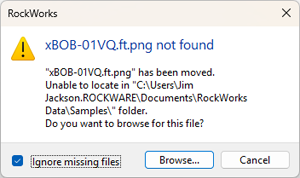
RockPlot3D - When opening an existing diagram with many linked, but missing, files the dialog to browse for the files includes a checkbox to ignore the warning for missing files.
(020) 02/04/26/JCJ - Bug Fix:
RockPlot3D zooming to a node and saving views, then returning to a view later will adjust the font appropriately and center that view.
(019) 02/04/26/JCJ - Bug Fix:
Importing a Shapefile through a Playlist - the Elevation option is updated in the menu item and honored in the import.
(018) 02/04/26/JCJ - Bug Fix:
Windows Clipboard is no longer cleared when clicking on Edit menu items in RockPlot3D.
(016) 02/04/26/JCJ - Improvement:
In RockPlot3D the mouse scroll wheel will only increase/decrease the Zoom when the mouse is over the diagram. If the mouse is over the TreeView of objects it will scroll the TreeView, not affecting the Zoom.
(015) 02/04/26/JPR - Cosmetic:
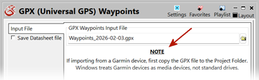
The Datasheet | File | Import | GPS Track and GPS Waypoints menus now include a warning to avoid trying to read files directly from the device.
(014) 02/02/26/JPR - New Feature:
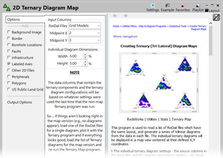
The Ternary Map program interface has been re-designed to emphasize how the program works in conjunction with the Ternary (single) program.
(013) 01/27/26/JPR - New Feature:
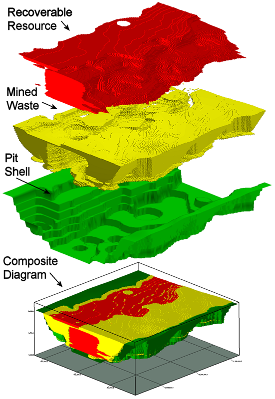
The ModOps | Volume | Extract Via Surface Excavation now plots the ore in red, waste in yellow and the pit shell in green.
(012) 01/26/26/JPR - New Feature:
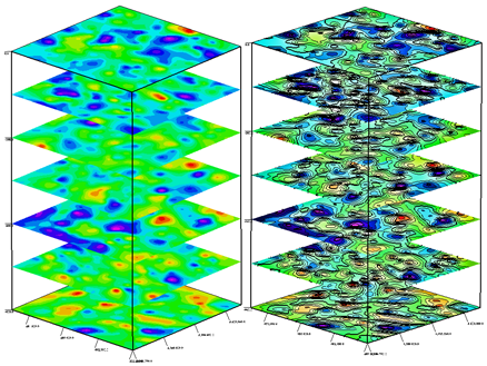
Contour lines may now be included within the surfaces generated by the ModOps | Grid | Grids | 3D Stack Diagram program.
(011) 01/24/26/JPR - New Feature:
Lithology Volumetrics has added functionalities. Double-clicking on a lithology model within the 3D display window will now open an enhanced version of the volumetrics window that includes several important new features:
Click to view this Write Up from the online Knowledge Base and learn more.
(010) 01/22/26/JPR - Removal:
The long-since deprecated (obsolete) programs listed within the Utilities | Misc. | Obsolete Programs pull-down menu have been removed from the program. Getting rid of these obsolete programs reduces the RockWorks "footprint" (i.e., download time, memory load, and instabilities).
(009) 01/22/26/JPR - Improvement:
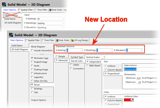
The Data Columns tab within the ModOps | Solid | Display program menu has been removed. Instead, the column designations have been moved into the Points sub-menu. This makes more sense given that the optional point-plotting is the only portion of this program that uses the XYZ coordinates. This redesign also eliminates the implicit question of "Why are XYZ coordinates required to display a solid model?". The same modifications have been made to the ModOps | Solid | Display as IsoShells program.
(008) 01/21/26/JCJ - Improvement:
For RockPlot3D, we've improved the import and export of DXF files using True Color (RGB) values.
(007) 01/21/26/JPR - Improvement:
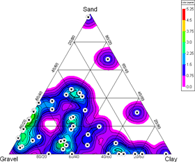
The sample density contouring within the ternary diagrams has been improved.
(006) 01/21/26/JPR - Improvement:
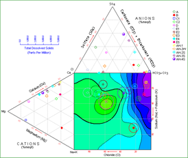
The TDS contouring within the Durov diagrams has been improved.
(005) 01/21/26/JCJ - Improvement:
RockPlot2D can now import and export DXF files using True Color (RGB) values.
(004) 01/16/26/JCJ - Bug Fix:
The “Include Elevations” setting is now being read when importing a Shapefile, instead of using the default value.
(003) 01/16/26/JCJ - Bug Fix:
Resolved a placement bug in the RockPlot2D Google Earth export for Profiles/Sections, where increasing vertical exaggeration caused the exported panel to appear progressively higher above the ground. The export now adjusts the top of the graphic for VE while keeping the bottom anchored, so the specified offset remains consistent.
(002) 01/05/26/JCJ - Improvement:
RockWorks has been updated to use the OXml library. The NativeXml library has been removed. The main areas this affects: RockPlot3D (rw3D), KMZ/KML, Collada export, Utitlities data (rwdat), IHS Depth Register File (XML format), Downloadable files utility (Help | Download | Misc. Downloads), loading XML resource files, and import templates.
(001) 01/03/26/JPR - New Feature:
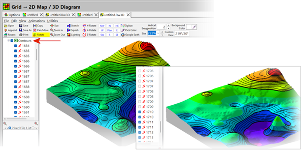
Expanding the Contours option within RockPlot3D will now show the z-values for each contour polyline thereby providing a means for selectively controlling which contours are visible. Toggling a contour between the on/off states also provides a way to identifying a specific contour.
NOTE: If you are using a NETWORK license, RockWorks20 v. 2022.5.28 and newer require the RockWare Network License Administrator version 1.18 or newer. Check with your license administrator before installing the RockWorks update.