new versions
RockWorks15
RockWorks15 2010.4.15 available
 New features in the latest build of
RockWorks15: New features in the latest build of
RockWorks15:
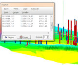
* Digitize XYZ coordinates in RockPlot3D.
* View
World Coordinates of any point in RockPlot3D.
*
Create borehole location maps in Google Earth.
*
Export downhole log data to ESRI 3D Shapefiles with
data attributes for display & analysis in ArcScene.
*
Save/load project dimensions for sub-projects.
*
Save profile locations for easy scripting.
* Import stratigraphy tops from a spreadsheet listing
depths or elevations.
* Multi-threading added to selected gridding and solid
modeling algorithms - much faster.
*
New grid and solid modeling resampling tools - much
faster.
* Much more.
Read more
Download Demo
RockWorks15 pricing
Back to top

AquaChem 2010.1
New version available
Here are just some of the
added features in this new version of AquaChem:
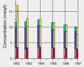
* Stacked Bar Chart - see temporal changes in
the ion balance of major anion/cations
* Grouped Box and Whisker Plot - compare
plots belonging to different domains/areas
* Generate multiple Time Series, Detection Summary,
and Box & Whisker Plots using Batch Mode
* Enhanced Durov Plot
* Import and display hydrographs on time
series plots to compare and correlate to trends
in water quality
* Link AquaChem project to a Hydro GeoAnalyst
(HGA) SQL Database
* Compare samples to U.S. EPA Hardness-Dependent
standards
* Enhanced Query functions
* Much more
Read more
AquaChem pricing Back to top
Surfer 9
Surfer
9.9.785 Update
 A
new build is available for Surfer 9. Licensed users can use
the Help / Check for Update menu command to download
the update automatically. A
new build is available for Surfer 9. Licensed users can use
the Help / Check for Update menu command to download
the update automatically.
Surfer 9 enhancements:
* UTM to State Plane translations
* Grid node editor
* Grid model imports
* DXF imports
* WMF, DXF, PDF exports
Read more
Download demo
Surfer pricing
Back to top
Spheristat 3
New version available
SpheriStat
3 contains these new features, and more.
 *
Compatible with Vista and Windows 7 *
Compatible with Vista and Windows 7
* Customize your map and net symbols
* Change default map and net symbol sets
* Publish datasets with custom symbols included
*
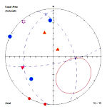
Display planar data as pole trend and plunge
* Added output options for analyses
* Dataset size limited only by available computer
memory
Read more
Download demo
SpheriStat pricing
Back to top
DeltaGraph 5.x
Special Pricing & Free Upgrade
 DeltaGraph
- the popular graphing software - has a new version
coming soon. Effective April 15 2010, a
$100 discount will apply to commercial and
academic licenses of DeltaGraph 5. And,
DeltaGraph 5 purchases made March 1, 2010 and after
will receive a free upgrade to DeltaGraph 6.0 upon
its release. DeltaGraph
- the popular graphing software - has a new version
coming soon. Effective April 15 2010, a
$100 discount will apply to commercial and
academic licenses of DeltaGraph 5. And,
DeltaGraph 5 purchases made March 1, 2010 and after
will receive a free upgrade to DeltaGraph 6.0 upon
its release.
Coming in DeltaGraph 6:
* User interface enhancements for the latest Mac OS
& Windows releases
* International text support
* Cross-platform document files
* Support for Pantone (R) & other 3rd-party spot
colors in PDF & EPS exports
* Greatly improved chart rendering quality in
Windows
Read more
DeltaGraph pricing Back to top
CTD-Diver
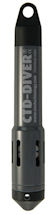
Special pricing while supplies last
The
CTD-Diver sets the standard for reliability
and longevity in groundwater quality monitoring.
The CTD-Diver is a fully stand-alone datalogger with
built-in memory, battery and sensors. Its ceramic
casing and unparalleled conductivity measuring range
(0-80 mS) make the CTD-Diver suitable for use at
every measuring site.
The CTD-Diver is impervious to the most aggressive
substances found in water environments. If offers
simultaneous measuring of groundwater level,
temperature, and conductivity. These are measured at
time intervals pre-defined by the user, and stored
in the datalogger's memory for readout at any time.
Read more
Contact
RockWare for pricing. Please be sure to specify your locale. Back to top
TIPS
RockWorks15: Working with
Sub-Projects
Use the Sort, Query and Project Dimensions
tools to group and model boreholes within a project.
For example, let's say that you have a project in
which there are dozens of quarries within a linear
deposit that extends over several miles. You could
create separate RockWorks projects for each quarry,
but managing the lithology and stratigraphy types
would be unwieldy. And managing boreholes in-between
the quarries would also be troublesome.
Instead, you can classify your boreholes with a site
name, sort the boreholes by site, query the holes by
site, and save/load specific project dimensions by
site.
1. Add a custom field to the Location table named
Site: Open your project in RockWorks and
right-click anywhere on the Location datasheet and
select Choose Optional Fields. Click the Add a
New Field button and name it "Site" as a String
field.
2. Enter the Site names for your boreholes. An
easy way to do this for existing boreholes is to
File / Transfer the locations to the Utilities
datasheet, enter the Site names in the Site column
for all the holes, and then File / Transfer the data
back to the Borehole Manager.
3. Sort the boreholes by Site name: Use the View /
Change Sort of Boreholes menu option to define the
Site field as the primary sort field. (You can
then add Name or other field as the secondary sort.)
4. Enable only those boreholes in a selected Site by
clicking manually, or (easier) using the View /
Filter Boreholes query tool to enable only those
holes with Optional Fields / Site / Equal To the
site name you enter.
5. Use the Scan Enabled Boreholes button to scan for
project dimensions using those enabled holes.
Fine-tune these (e.g. node spacing) as necessary.
6. Use the Save Dimensions to File button to save
these project dimensions for later retrieval.
Read more
Download demo
Back to top
|