If you have a RockWorks license with expired maintenance contact RockWare, or visit the RockWare Customer Portal to renew your maintenance so that you can update to the new version.
If you are using RockWorks20xx and are current on maintenance, the 4-digit program name will move up to the current year "RockWorks2026" when you install the first release of each new year.
Click HERE And scroll below the image to download the Free Trial
A note about file syncing while working in Rockworks. When your projects are stored with programs like OneDrive or Dropbox, you may experience delays in saving from RockWorks or receive errors about the database being unavailable (unable to save). This is because both programs are trying to sync simultaneously. If you want to avoid this inconvenience, please pause the SYNC feature in the storage programs while working in RockWorks. Also, when using OneDrive with RockWorks, it is NOT recommended that the Documents folder be remapped to OneDrive.
(095) 06/29/26/JCJ - Bug Fix:
(095) 06/29/26/JCJ - Bug Fix:
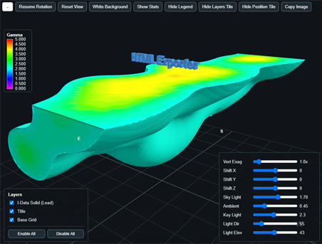
RockPlot3D Solid Model voxel displays have been updated so that the Smooth/Flat shading option is applied when drawing voxels. Smooth mode now uses interpolated corner normals, while Flat mode retains face-based normals.
(095) 06/29/26/JCJ - Bug Fix:
Resolved an issue in Grid | Create | XYZ - Grid where datasheet Z values could be incorrectly converted from feet to meters when using a custom PRJ coordinate system with survey-foot units. Grid Z values now use the project vertical units instead of the coordinate-system output units during gridding.
(094) 06/29/26/JCJ - Bug Fix:
Time Graph was loading the shared TDATA_0 filter settings, which included the hidden RESAMPLE flag from other T-Data menus. Now, G_Filter.resample is cleared immediately after loading that shared filter, so Time Graph still uses the normal T-Data extraction path but ignores resampling since there’s no Time Graph UI option for it.
(093) 06/29/26/JCJ - Bug Fix:
Instead of an access violation when closing a RockPlot3D file, The object tree now moves focus away from the ElXTree control before its items are destroyed during shutdown.
(092) 06/24/26/JCJ - Bug Fix:
The Color Model horizontal and vertical slices in RockPlot3D display solid slice faces while the view is static, instead of only showing their wire outlines during rotation.
(091) 06/23/26/JCJ - Bug Fix:
RwMenu files are now being listed in the project manager and can be opened with a double click. Also, when rwmenu files are opened in RW2026, they are converted using the Playlist converter.
(090) 06/22/26/JCJ - Bug Fix:
RockPlot2D Profile export to RockPlot3D access violation is resolved by clamping profile bitmap crop rectangles to PNG bounds before embedding panels.
(089) 06/22/26/JCJ - Improvement:
RwMenu files are now being listed in the project manager and can be opened with a double click. Also, when rwmenu files are opened, they are converted using the Playlist converter.
(088) 06/16/26/JPR - Bug Fix:
Fixed RockPlot2D EMF/WMF export sizing when manual vertical exaggeration is used, preventing oversized imports in applications such as Adobe Illustrator.
(087) 06/15/26/JPR - New Feature:
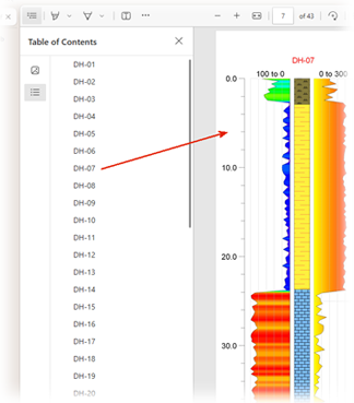
The PDF file created by the Borehole Operations / Striplogs / All Logs / PDF program now includes a "Table of Contents" strip along the left side of the PDF file that will allow you to navigate to other logs within the PDF. Click on the help button with the menu to learn more.
(086) 06/15/26/JPR - New Feature:
The Borehole Operations / Maps / Borehole Map / Output Options list now includes an item titled "HyperMap". This new option is used to create an interactive HTML version of the borehole map that is viewable within a web browser. Clicking on a borehole symbol within this map will display borehole log diagrams within the PDF file created with the Borehole Operations / Striplogs / All Logs -> PDF program. Click on the Help button within the menu to learn more.
(085) 06/14/26/JPR - Improvement:
Added live refresh support for datasheet column-selection menus in these program option areas, so open menus update their column lists after datasheet columns are changed: Block Labels; Circular Symbols; Colored Raster Symbols; Convex Hull; Copy File List; Extract Values; File List; Google Earth Cylinders; Grid Evaluate; Hyperlinks; Vertical Image Margins; 2D Montage; Object Size; Polyline to 3D Faults; 3D Points; Polygons to Solid; 2D Polyline; Polyline Export; Replace Text; Scattergram Border; Solid Evaluate; Table-Based Raster Symbols; Ternary Map; Time Mass; 3D Tubes; Uniform Raster Symbols.
(084) 06/09/26/JCJ - Improvement:
Added a DXF 2D import option to import closed DXF polylines as RockPlot2D polylines instead of filled polygons. This allows closed contour loops from CAD files to retain their Z/elevation values so they can be used by the Contours | Grid program, while preserving the previous polygon import behavior by default.
(083) 06/09/26/JCJ - Improvement:
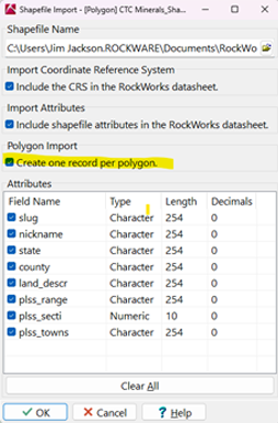
Added a datasheet shapefile polygon import option to create one row per polygon instead of one row per polygon vertex. When enabled, the import includes Polygon #, Min X, Min Y, Max X, and Max Y columns along with the selected DBF attributes. This makes it easier to import polygon-level data such as PLSS lease-map attributes. The existing vertex-per-row import behavior remains unchanged by default.
(082) 06/08/26/JPR - Improvement:
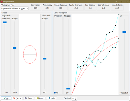
The lag points within the variogram editor have been changed from small, hard-to-see crosses to small black dots.
(081) 06/08/26/JPR - Improvement:
The "Pre-Model Points For Variograms" within the Solid Kriging menu is now multithreaded - meaning that it's significantly faster.
(080) 06/08/26/JPR - Improvement:
The ModOps | Solid | Statistics | Residuals program is now multithreaded - meaning that it's significantly faster.
(079) 06/07/26/JPR - Improvement:
The ModOps | Grid | Statistics | Residuals program is now multithreaded - meaning that it's much faster.
(078) 06/07/26/JPR - Improvement:
The Radial Basis Function (RBF) solid modeling better supports faulting.
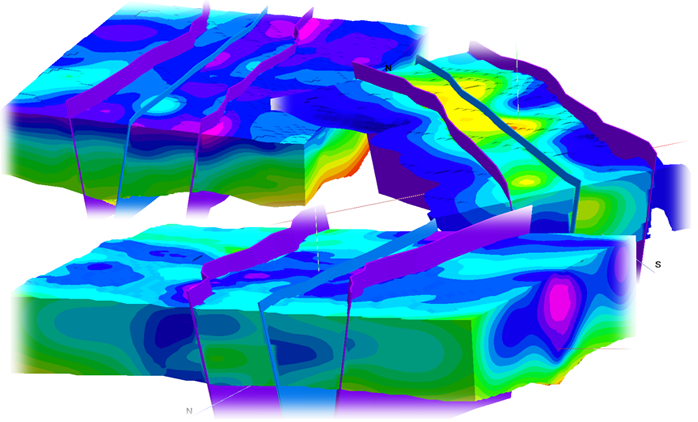
(077) 06/07/26/JPR - Improvement:
Fixed Single Spoke kriging variogram handling so the correct variogram is used in 2D and 3D kriging, and corrected Single Spoke option indexing in 3D metadata and 2D variogram setup.
(076) 06/07/26/JPR - Improvement:
Changed kriging variogram output labels from “Relative Sill” to “Sill” because the reported value is the variogram sill/semivariance coefficient, not a normalized relative sill.
(075) 06/06/26/JPR - Improvement:
Improved 3D kriging solid modeling speed while preserving model quality by using parallel processing and balanced sample selection around each voxel.
(074) 06/06/26/JPR - Improvement:
Added support for verticalized/TVD deviated boreholes within the Stratigraphy | Section | Linear Correlation program.
(073) 06/04/26/JPR - Improvement:
The little red and blue questions marks that adorn many menus have been standardized to blue and the pull-down menus that most of them trigger now include options for viewing the RockWorks Training page and the RockWare Knowledge Base.
(072) 06/04/26/JPR - Improvement:
Help hints have been added to 301 RockWorks buttons and typos with 20 help hints have been fixed.
(071) 06/04/26/JPR - New Feature:
The Execution History page now has a "Copy to Clipboard" button. If clicked, the contents of the history list will be copied to the Windows clipboard.
(070) 06/03/26/JPR - Bug Fix:
The Size option within the RockPlot3D menu now responds correctly to a size that is manually entered.
(069) 06/02/26/JPR - Improvement:
When running a Playlist, 2D and 3D diagrams are no longer displayed in separate dialog windows before being plotted within a Playlist tab.
(068) 05/31/26/JPR - Improvement:
RockWorks automatically creates backup copies of your playlist files and project settings before making changes to them. These backup files are saved in the Backup subfolder within your project folder.
(067) 05/31/26/JPR - Bug Fix:
Onlap/underlap only adjusts cells that already exist in the current formation and have valid top and base elevations. It does not create new cells from blank areas, and it does not let blank areas in neighboring formations shrink the current formation.
(066) 05/29/26/JPR - Improvement:
When generating layered stratigraphic models or stratigraphic block models, units within the Stratigraphy Table that have an unchecked Show-In-Legend setting now log a "quiet note" within the execution log rather than displaying a warning message. This eliminates interruptions when processing a playlist.
(065) 05/27/26/JCJ - Improvement:
License Administrator Update: Added thread synchronization to the Network License Server using TCriticalSection to protect shared licensing state across concurrent Indy client threads. Shared access to license records, user datasets, license counts, loan data, and license request processing is now serialized to prevent race conditions, intermittent lookup failures, duplicate license allocation, and dataset corruption during simultaneous checkout, heartbeat, borrow, return, and status operations. Improved server shutdown sequencing to safely stop active client contexts before releasing shared resources.
(064) 05/15/26/JPR - Improvement:
The Playlist menu now has an option to pick a recent playlist from a history list
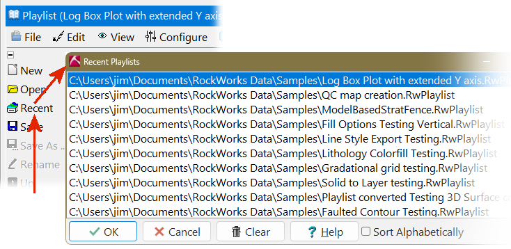
(063) 05/14/26/JPR - Improvement:
When closing the program, the "Save Warning" now has an option titled "No to All" that will skip subsequent save warnings and discard any unsaved changes to RockPlot2D and RockPlot3D files.
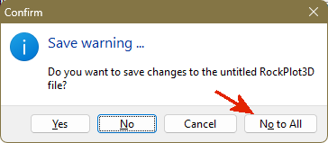
(062) 05/14/26/JPR - Improvement:
RockWorks now provides a notice when an older Project.ini file is updated.
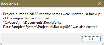
(061) 05/14/26/JPR - Improvement:
Eight new hydrological symbols have been added to the raster symbol library.
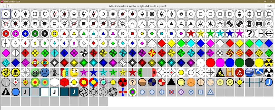
(060) 05/14/26/JPR - Improvement:
The following changes have been made to the RockPlot2D | Edit | Copy Image and RockPlot3D | Edit | Copy Image operations.
(059) 05/05/26/JCJ - Improvement:
Borehole Operations - Lithology | Solid - 3D Solid Diagram | Block Diagram Filter option filters the diagram for the selected Lithology G-Values.
(058) 05/04/26/JCJ - Bug Fix:
RockPlot3D Point Digitizing / Export to Borehole Database will now work, even when using a fixed elevation, so that users can choose the Collar Elevation.
(057) 04/29/26/JPR - New Feature:
The title-block text auto sizing has been updated for multi-line peripheral title blocks and allows the text to fit within their designated boxes more reliably.
(056) 04/29/26/JCJ - Bug Fix:
Fixed issue where pasted numeric/date values (e.g., from Excel) were rejected due to hidden whitespace. Now the paste process uses normalized input with field 'OnSetText' handlers.
(055) 04/29/26/JPR - Bug Fix:
RockPlot2D drawing tools can be selected after zooming into a newly opened map/diagram instead of the zoom button state forcing the program back into zoom mode.
(054) 04/28/26/JPR - Bug Fix:
Fixed the Utilities | Maps | Point Symbols program such that points still plot when Z values are enabled but individual Z cells are blank.
(053) 04/28/26/JPR - Bug Fix:
Fixed the Utilities | Animate | Grids | Contour Map Animation program such that animation color palettes no longer shift unexpectedly.
(052) 04/28/26/JPR - Bug Fix:
Fixed the Utilities | Animate | Grids | 3D Surface Animation program such that animation color palettes no longer shift unexpectedly.
(051) 04/28/26/JPR - Bug Fix:
Fixed the Utilities | Animate | Solids | 3D Animation program such that animation color palettes no longer shift unexpectedly and RockPlot3D flashes less during frame rendering.
(050) 04/28/26/JPR - Bug Fix:
Fixed the Utilities | Animate programs such that cleanup after animation processing no longer causes history/logging access violations.
(049) 04/28/26/JPR - Bug Fix:
Fixed the Utilities | Images | Logarithmic Digitizing program such that the Logarithmic help button opens the correct help topic.
(048) 04/28/26/JPR - Bug Fix:
Borehole Operations | Lithology | Volumetrics Improvements:
(047) 04/28/26/JPR - Bug Fix:
RockPlot3D | Lithology Model Options dialog Fixes:
(046) 04/28/26/JPR - Bug Fix:
Fixed 2D map programs that use logical color maps such that shaded relief is not incorrectly applied to logical true/false color fills.
(045) 04/28/26/JPR - Bug Fix:
Fixed older project loading such that legacy contour/color settings are preserved when older projects are opened.
(044) 04/28/26/JPR - Bug Fix:
Fixed the Borehole Operations | Maps | Location Map program such that transect endpoint labels use the correct table-based labels and that transect profile endpoint labels no longer inherit section label offset and font settings.
(043) 04/28/26/JPR - Bug Fix:
Fixed the Borehole Manager | QuickMap tab such that option pop-downs appear in the correct screen location.
(042) 04/28/26/JPR - Bug Fix:
Fixed In RockPlot3D:
(041) 04/28/26/JPR - Bug Fix:
Fixed the Project | New, workflow such that the old project’s datasheet is closed after a new project is created.
(040) 04/28/26/JPR - Bug Fix:
The Borehole Operations | I-Data | Resample program is set up so that the weighted-average resampling uses the interval center.
(039) 04/24/26/JPR - Bug Fix:
Fixed the Utilities | Solid | Extract Grid(s) | Solid to Grids program such that non-whole slice elevations are preserved in output grid/map names instead of being rounded.
(038) 04/24/26/JPR - New Feature:
Creating a new project or changing the project now clears the main datasheet only if the project folder actually changed. This fixes instances in which an old project’s datasheet stayed open in the new project, while still avoiding a wipe if the user cancels the New Project dialog. If the datasheet has not been saved, the user will be given an opportunity to save it!
(037) 04/06/26/JPR - Bug Fix:
Logarithmic histograms allow the Show Legend option to be enabled (without access violation errors).
NOTE: If you are using a NETWORK license, RockWorks20 v. 2022.5.28 and newer require the RockWare Network License Administrator version 1.18 or newer. Check with your license administrator before installing the RockWorks update.