If you have a RockWorks license with expired maintenance contact RockWare, or visit the RockWare Customer Portal to renew your maintenance so that you can update to the new version.
If you are using RockWorks20xx and are current on maintenance, the 4-digit program name will move up to the current year "RockWorks2026" when you install the first release of each new year.
Click HERE And scroll below the example image to download the Free Demo version
A note about file syncing while working in Rockworks. When your projects are stored with programs like OneDrive or Dropbox, you may experience delays in saving from RockWorks or receive errors about the database being unavailable (unable to save). This is because both programs are trying to sync simultaneously. If you want to avoid this inconvenience, please pause the SYNC feature in the storage programs while working in RockWorks. Also, when using OneDrive with RockWorks, it is NOT recommended that the Documents folder be remapped to OneDrive.
(023) 09/23/26/JCJ - Improvement:
Fixed Polygon List maps incorrectly displaying solid polygon borders as dashed, dotted, or wavy lines. This helps keep mapped polygon boundaries visually consistent with the solid-line style selected for the map.
(022) 09/23/26/JCJ - Improvement:
Fixed RockPlot2D legend titles becoming progressively smaller when vertical exaggeration was applied. Legends remain readable when a 2D diagram is displayed with vertical exaggeration.
(021) 09/23/26/JCJ - Improvement:
Fixed I/P/T column-based Excel imports so configured synonym/alias tables are applied correctly, including when only some data tracks have synonym tables. This helps ensure imported interval, point, and time data use the configured aliases without requiring every track to have a synonym table.
(PDF) 09/17/26/TEAM - Improvements:
Click to view the PDF Summary of the Q3 2026 improvements, fixes, and updates. This is an extensive list posted in the RockWorks Online Knowledge Base.
(PDF) 08/19/26/TEAM - Improvements:
Click to view the PDF Summary of the early Q3 2026 improvements, fixes, and updates. This is an extensive list posted in the RockWorks Online Knowledge Base.
(020) 08/17/26/JCJ - Improvement:
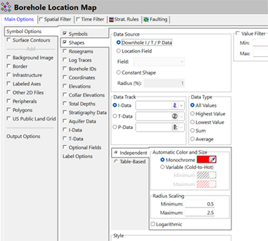
Added constant shapes and proportional shapes based on numeric Location-table fields to Borehole Location map overlays. For example, borehole locations can be marked with symbols sized according to a numeric field, making differences between locations easier to see on a map.
(019) 08/17/26/JCJ - Improvement:
Consolidated RockPlot2D section panels exported to RockPlot3D into a single “Section” group, allowing the entire section to be turned on or off easily. This makes it easier to show or hide a complete exported section in a 3D scene without managing its panels individually.
(018) 08/17/26/JCJ - Improvement:
Added an option to place major and minor contours in separate RockPlot2D layers, allowing minor contours to be toggled independently. For a busy contour map, minor contour lines can now be hidden while major contours remain visible.
(017) 08/17/26/JCJ - Bug fix:
Striplog Section vertical-axis annotations so elevation-based labels display elevations rather than depths, while preserving independent meter and feet units for the left and right axes. This makes it easier to interpret section elevations correctly when reviewing striplogs with different axis units.
(016) 08/11/26/JCJ - Improvement:
Fixed Strat Picker striplogs and stratigraphy being compressed or invisible when Vertical Alignment was set to Actual Elevations. This allows users to view Strat Picker striplogs at their actual elevations without the display collapsing or disappearing.
(015) 08/11/26/JCJ - Bug Fix:
R3DIM dimension changes now mark the RockPlot 3D diagram modified. Saving synchronizes the current dimensions, zoom, pan, rotation, and text scale with the RW3D Default View. Reopening now honors the saved view instead of overwriting it with automatic zoom. Users who adjust a 3D view can save and reopen the file without losing the intended view settings.
(014) 07/24/26/JCJ - Improvement:
Corrected the native GeoTIFF importer to reproject raster elevations into the project coordinate system and accurately calculate projected raster extents. Also corrected the native GeoTIFF reprojection, projected extent calculation, and grid node allocation to match the project extents and spacing This helps imported elevation rasters line up with the project coordinate system and intended grid dimensions.
(013) 07/21/26/JCJ - Improvement:
Grid | Export | GeoTIFF - Added GeoTIFF export for grid models, preserving grid values, spatial extents, cell spacing, NoData values, and coordinate-system information for use in GIS applications such as ArcGIS Pro. This allows grid results to be transferred to GIS software while retaining their spatial reference and missing-data information.
(012) 07/21/26/JCJ - Improvement:
Added a RockPlot2D utility to calculate and copy the areas of all visible stratigraphic units in every section panel at once. For multi-panel stratigraphic sections, users can collect the visible unit areas in one operation rather than measuring each panel separately.
(011) 07/21/26/JCJ - Improvements:
Fault Menu Improvements Added: 2D map or 3D diagram output options to all fault-import commands, Maps display faults only when the import adds said fault, and now Preserves the standalone Fault Display menu. This makes it easier to review newly imported faults in a 2D map or 3D diagram without displaying unrelated faults.
(010) 07/20/26/JCJ - Update:
Corrected tiles in solid modeling with Vertical Search Cutoff so cutoff distances are evaluated using original project elevations, preventing valid voxels above borehole bases from being incorrectly assigned null values.
(009) 07/20/26/JCJ - Bug Fix:
Fixed OBJ color legend exports to match RockPlot3D by using the correct displayed range values, aligning labels with their color boundaries, and positioning the legend title above the color bar. Categorical legend labels remain centered on their corresponding entries. Exported OBJ legends more accurately reflect the colors and values shown in RockPlot3D, reducing confusion when sharing a model.
(008) 07/17/26/JCJ - Bug Fix:
Fixed a problem that prevented Borehole Survey and other tools from opening RwDat output in a new tab when Windows regional settings used a comma as the decimal separator. Users working with Windows regional settings that use decimal commas can open the generated RwDat output without this error.
(007) 07/15/26/JCJ - Improvement:
Added an Advanced-license Playlist command that runs another Playlist and then resumes the caller, with protection against direct and indirect recursive calls. Nested file calls support both RockWorks Playlists and Command Scripts. This supports modular automation workflows in which a main Playlist runs a reusable set of steps and then continues.
(006) 07/13/26/JCJ - Improvements:
Wishlist Items Added: Added Left, Center, and Right alignment options to the 2D Striplog Title settings, Center is the default for new or missing settings, Titles now use true Anchor Text alignment over the log axis, Anchor Text borders and bounds follow the selected alignment, Added symbol preview/selector to the RockPlot3D Digitize window, Added marker size control as a percentage of the diagram diagonal, Default marker is 0.25%, substantially smaller than the previous 1%-diameter sphere, Symbol, color, and size persist between sessions, and others.
(005) 07/13/26/JCJ - Improvement:
Fixed a GT Volumetrics crash that could occur when running ModOps | Volume | Thickness -> GT Grid . The weighted statistics routine was freeing the temporary mass grid twice, causing an invalid pointer operation during TRW_Grid.Destroy; the grid is now released only by the existing cleanup block. This prevents a crash when calculating a grade-thickness grid with the affected volumetrics tool.
(004) 07/10/26/JCJ - Improvement:
The SQL Server/ODBC lookup loading in Borehole Manager tabs was made better by prefetching lookup/type datasets before parent table lookup-field binding, preventing "connection is busy with results for another hstmt" errors. This allows users connected to SQL Server through ODBC to load Borehole Manager lookup fields without the previous connection-busy error.
(003) 07/10/26/JCJ - Bug Fix:
Fixed Stratigraphy/HydroStratigraphy depth conversion for mixed-unit projects. Single-interval stratigraphy data now converts database depth values from Project.ZUnits to Project.OutZUnits before plotting/exporting, matching other borehole depth data when output units are feet or meters. This keeps plotted or exported stratigraphic intervals at the correct depths in projects where stored and output depth units differ.
(002) 07/07/26/JCJ - Bug Fix:
The Borehole Manager | File | Import | Database wizard won't cause the SQL Server / ODBC imports to fail with a “Connection is busy with results for another hstmt” error. The import now fully retrieves the active source result set before using its record count, preventing overlapping statements on the same SQL Server connection. This allows SQL Server/ODBC database imports to complete without the previous overlapping-query error.
(001) 07/06/26/JCJ - Improvement:
Added an option to the Borehole Map Stratigraphy Data labels to plot the value from a selected user-defined Stratigraphy or Hydro-Stratigraphy field. This allows custom fields added to the stratigraphy tables to be included in borehole map labels with optional prefix and suffix text. For example, a custom stratigraphy field can be displayed beside borehole locations on a map without replacing the standard stratigraphic labels.
NOTE: If you are using a NETWORK license, RockWorks20 v. 2022.5.28 and newer require the RockWare Network License Administrator version 1.18 or newer. Check with your license administrator before installing the RockWorks update.