
If you have a RockWorks20 license with expired maintenance, contact RockWare or visit the RockWare Customer Portal to renew your maintenance so that you can update to the new version.
If you are using RockWorks2021 and are current on maintenance, the 4-digit program name will move up to the current date"RockWorks2022" with the first release of each new year.
Download the RockWorks Free Trial (Demo)
(039) 09/21/22/JCJ - Improvement:
SQL Statements in a Playlist will now accept the concatenation operator '||' in the SQL statement.
(038) 09/21/22/JCJ - Improvement:
Added menu item for copying the litho-types table contents to the strata-types table and vice-versa. This can be used for folks who enter a bunch of data only to find that they it would be better to treat the lithology as stratigraphy or vice-versa.
(037) 09/21/22/JCJ - Improvement:
Added 'Edit' menu item to allow user to combine two data types. This works for Stratigraphy, Lithology, Well Construction, Aquifers, Bitmaps, I-Data, I-Text, P-Data, P-Text and T-Data Types Tables.
(036) 09/21/22/JCJ - Improvement:
Added menu item for Stratigraphy and Lithology Types Tables, the option to turn off all units/materials.
(035) 09/20/22/JCJ - Improvement:
3D Polynomial Trend Modeling changed to use dynamic arrays so it is no longer limited to 2000 points, and all the points are added at once to eliminate re-dimensioning the array at each point.
(034) 09/12/22/JPR - Cosmetic:
The Total Nodes listing within the Project Dimensions summary bar no longer shows zero if the number of nodes exceeds 32,627.
(033) 09/12/22/MIW - Improvement:
The X and Y axes of Scattergrams can now be plotted either descending or ascending order.
(032) 08/20/22/JPR - New Feature:
The ModOps / Grid / Replace option has been split into two sub-options:
(031) 08/19/22/MIW - New Feature:
Macros for File Date and Time have been added to the ReportWorks Text and Multiline Text.
(030) 08/17/22/MIW - New Feature:
Lithologic Models are now displayed with a new object that allows the user to turn on and off lithologic units. Volumetrics are updated with each change.
(029) 08/16/22/JCJ - Improvement:
In the LAS Import, selecting to import to an existing borehole will copy in the Easting, Northing, Elevation and Total Depth from that borehole to their respective fields so that they are not overwritten.
(028) 08/10/22/JPR - New Feature:
The Graphics / Images / Vertical / Multiple program now includes a tab labeled “Margins”. This provides the same functionality as the Vertical / Single program however it also includes an option for defining the margins of each individual image by using columns within the datasheet
(027) 08/10/22/JPR - New Feature:
The Graphics / Images / Vertical / Single program now includes a tab labeled “Margins”. If enabled, the endpoint coordinates are projected outward to accommodate additional annotation outside of the actual profile. This solves a problem with annotated diagrams in which the profile location was defined by the image rather than the profile itself. In order to use this new feature an image manipulation program such as the free Windows Paint program must be used to determine the margin dimensions.
(026) 08/08/22/MIW - Improvement:
A concentration option has been added to the Inverse Distance Weighting algorithm for gridding, It adds a non-linear weighting based on distance to the modelling to show a concentrated contouring around data points.
(025) 08/04/22/JPR - New Feature:
A button titled "Close Sub-Menus" has been added to the Layout pull-down menu. This option will close all non-modal menus that are currently open. A "modal window" is a dialog that disables the main RockWorks menu but keeps it visible.
(024) 08/04/22/JPR - Bug Fix:
If less than two boreholes are selected when using the Borehole Manager / Striplogs / Lithology Picker or Stratigraphy Picker, and the Continue button is selected, the program will no longer generate an Access Violation error message.
(023) 08/04/22/JPR - Cosmetic:
If less than two boreholes are selected when using the Borehole Manager / Striplogs / Lithology Picker or Stratigraphy Picker, a more explanatory message will be displayed.

(022) 08/04/22/JPR - Cosmetic:
The message that appears upon startup without an internet connection is more explanatory.

(021) 08/03/22/JPR - New Feature:
A new option titled "Bubbles" has been added to the RockWorks Borehole Operations / Borehole Map program for adding proportionally scaled circles directly above downhole I-Data, T-Data, or P-Data.

(020) 07/30/22/JPR - New Feature:
The IsoMesh options within RockWorks now provide greater control over which lines will be plotted and their spacing.

(019) 07/30/22/JPR - New Feature:
The solid display options used by many of the RockWorks programs has been re-designed such that IsoMeshes may now be plotted in combination with a voxel diagram. The previous version was limited to only plotting IsoMeshes in combination with IsoSurfaces.

(018) 07/30/22/JPR - New Feature:
A new option titled "Isolate Geobody that Includes Point Source" has been added to ModOps Solid menu.
If the Isolate Geobody That Includes Point Source option is checked, the program will isolate only the geobody that includes the specified XYZ point. If the Isolate Geobody That Includes Point Source option is unchecked, the program will isolate and identify individual contiguous zones with g-values that fall within the cutoff range which do not connect with other zones.
(017) 07/29/22/MIW - Bug Fix:
The QuickMap display of the project image was not using the World File or Manual position settings.
(016) 07/28/22/KD - Upload:
New build of RockWorks loaded to webpage today, revisions, forum and help updated.
(015) 07/27/22/JPR - Cosmetic:
The Input/Output Models, Cutoff Levels, and Remove Smaller Geobodies submenus within the ModOps / Solid / Filters / GeoBody Filter menu have been consolidated into a single tabbed page.

(014) 07/26/22/JPR - New Feature:
The Input Columns sub-menu that is shared by the programs within the HydroChem menu (Durov, Piper, Schoeller, Stiff, Stiff Map, Ion Balance, Total Dissolved Solids, and Ion Report) now includes options (Figure 1) that determine if the input data is in mg/L (milligrams per liter) or mEq/L (milliequivalents per liter). If the mg/L option is selected the program will convert the input data to milliequivalents per liter using hardwired multipliers for the major ions (i.e., Na, Ca, K, Mg, Cl, HCO3, CO3, and SO4) and user-specified conversion factors for any additional ions. This is identical to how previous versions of the programs functioned. Conversely, if the input data is in mEq/L, no conversions will be performed and the Conversion Factors will not be displayed (Figure 2). As a consequence, the mEq/L option can be used to plot the ions in any concentration units (e.g., stones per ton).

(013) 07/22/22/MIW - Bug Fix:
The Graphics >Animate >RockPlot 3D File now correctly generates a video when using the Advanced option.
(012) 07/20/22/MIW - Improvement:
The IsoSurface display options now includes an option to display the cap and cutaways as contoured or solid.
(011) 07/18/22/JPR - Removal:
The gINT import option has been removed.
(010) 07/13/22/MIW - New Feature:
3D Faults can now be exported directly to DXF and Shape File formats.
(009) 07/12/22/JPR - Bug Fix:
The ModOps / Solid / Math / Solid Math / Constant divided by Solid option now works correctly. The previous version would fail to create a model.
(008) 07/11/22/MIW - New Feature:
2D Faults can now be exported to DXF and Shape File formats.
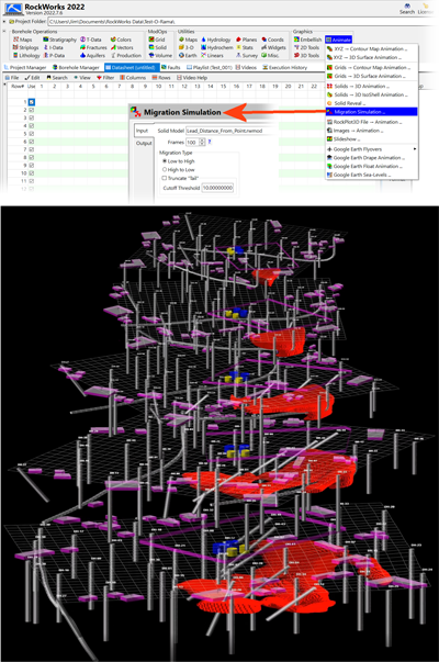
(007) 07/10/22/JPR - New Feature:
A new program titled "Migration Simulation" has been added to the Graphics / Animate menu. This program will create animations in which the low values migrate to the high values or vice-versa.
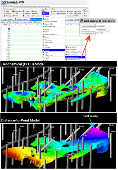
(006) 07/10/22/JPR - New Feature:
A new program titled "Distance to Point" has been added to the ModOps / Solid / Filters menu. This program will replace non-null nodes with values equal the straight-line distances between the nodes and a specified point source.
(005) 07/08/22/JPR - Improvement:
The "Use Faults" option within the solid model smoothing dialog is now disabled by default and the option title has been changed to "Use Faults (Very Slow)".
(004) 07/08/22/MIW - Improvement:
The coordinate minimum and maximum values have been added to the RockPlot3D file in order to make Embellishing the file clearer. Files will need to be resaved before the extents will be added.
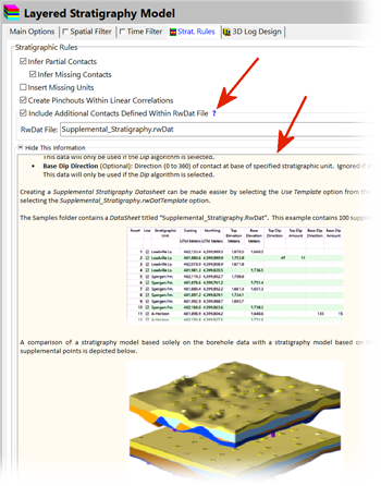
(003) 07/05/22/JPR - Cosmetic:
The "Strat Rules" tab now includes a blue help button adjacent to the 'Include Additional Contacts' option which will display detailed information about adding supplemental points to the stratigraphic modeling.
Read more in the Knowledge Base
(002) 07/03/22/JPR - Bug Fix:
The Utilities / 3-D / Triangle Mesh program no longer asks for a title column or line thickness and no longer plots duplicate sets of triangles.
(001) 07/03/22/JPR - Removal:
The Isosurface option has been removed from the Stratigraphy / Solid Model program.
NOTE: If you are using a NETWORK license, RockWorks20 v. 2022.5.28 and newer require the RockWare Network License Administrator version 1.16 or newer. Check with your license administrator before installing the RockWorks update. See our forum posting for details.