
Check out the New features in RockWorks.
If you have a RockWorks17 license which was current on maintenance as of May 2020, you should have received an email from us with your RW17 -> RW20xx license upgrade details. Please contact us if you did not receive this email.
If you have a RockWorks17 license with expired maintenance, contact RockWare or visit the RockWare Customer Portal to renew your maintenance so that you can update to the new version.
If you are using RockWorks2020 and are current on maintenance, the 4-digit program name will tick up to "RockWorks2021" with the first release of the new year.
Download the RockWorks Free Trial (Demo)
(060) 09/29/21/JCJ - Bug Fix:
Borehole Manager | Import Multiple Tables (Excel & Text) for the tables I-Data, I-Text, P-Data, P-Text, and T-Data the existing tracks will now be cleared when Replace Data is checked.
(059) 09/29/21/MIW - Improvement:
A Copy File command has been added to the Playlist Add menu at the top.
(058) 09/27/21/JCJ - Bug Fix:
Borehole Manager | Exports | ... All Tracks will now account for regional formatting (i.e. comma as a decimal separator) I-Data, I-Text, P-Data, P-Text, T-Data.
(057) 09/27/21/JCJ - Bug Fix:
Empty column values in the import are set to NULL for field values in Playlist CSV Import process.
(056) 09/21/21/JCJ - Bug Fix:
Borehole Operations Maps | Google Earth (Simple or Advanced) was giving a DB error. RockWorks allows CollarElevation to be NULL, however the function to choose the Elevation value when CollarElevation was NULL was making the field read-only.
(055) 09/21/21/JCJ - Bug Fix:
RockWorks will now allow coded Coordinate Systems (like epsg:2877) that are based in U.S. Surveyor's Feet.
(054) 09/21/21/JCJ - Bug Fix:
Upgrading a project from RW17 that uses a custom coordinate system and an "Init" style code (like epsg or esri) will succeed. The PROJ generic coordinate transformation software RockWare applies used to change how it handled "Init" parameters.
(053) 09/17/21/MIW - Improvement:
The RockPlot2D Color Legend now allows you to set a separate Text Interval form the Color Interval. The Text and Color Interval must both divide evenly into the Z Range and a warning will be issued by the dialog.
(052) 09/16/21/KD - Upload:
New version of RockWorks 2021 added to website and posted revisions to Forum.
(051) 09/15/21/JPR - New Feature:
The new (9/7/21) capability for including "supplemental points" when creating stratigraphic models based on borehole data has been enhanced to include optional dip information for the upper and lower contacts. Please note two caveats: (1) This information is only used if the Dip Direction algorithm is used to model the surfaces. (2) If a dip is specified for the top surface of a stratigraphic unit but no elevation is provided, the dip information will be ignored. The same applies to the base.
(050) 09/14/21/JPR - Bug Fix:
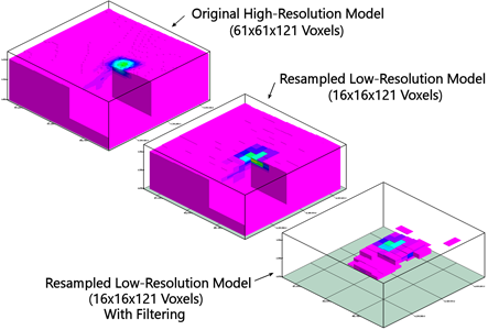
The filtering within the new Fine-to-Course solid modeling program now filters the input model correctly.
(049) 09/13/21/JPR - Bug Fix:
When tilting or warping I-Data, T-Data, etc. models in conjunction with superface or subface model truncation, the program no longer produces strange gaps between the model and the truncation surface. Special thanks to Alison for taking the time to illustrate the problem within a Playlist. It shaved at least a day off the de-bugging.

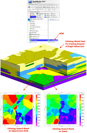
(048) 09/09/21/JPR - New Feature:
The Borehole Operations / Lithology / 2D Isopach option now displays two options: Voxel-Based and Grid-Based. The Grid-Based option behaves just like the previous version meaning that it generates surfaces based on the uppermost and lowermost occurrences of the selected lithology and then subtracts the lower from the upper surface to created the isopach grid. The new Voxel-Based option simply adds the heights of all voxels that are equal to the designated lithotype to produce the isopach. This new approach will account for voxels in-between the uppermost and lowermost occurrences that don't equal the selected lithotype (i.e. interbeds).
(047) 09/09/21/JCJ - Bug Fix:
Project Folder | New - Creating a project based a custom coordinate system using an EPSG code no longer adds the "+init" to the parameter string (the +init was invalid).
(046) 09/09/21/JCJ - Enhancement:
The editor for editing a database memo field in the Borehole Manager, like the comments in Lithology, has been more streamlined. There is now an OK and Cancel button on the bottom of the editor to either save back to the database or cancel the changes. The Save button is not shown but if the user wants to write out to a text file they can still choose Save from the menu.
(045) 09/08/21/MIW - Bug Fix:
The text position for IData, IText, TData, Stratigraphy Text and Lithology Text in 2D Striplogs is now honored.
(044) 09/08/21/JPR - New Feature:
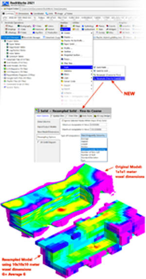
A new program titled "Resample (Fine-to-Coarse)" has been added to the ModOps / Solid / Math sub-menu. This program is used to convert high-resolution solids to low-resolution solids based on a variety of options as shown below.
(043) 09/07/21/JPR - Bug Fix:
The Hybrid grid modeling no longer generates an Access Violation error inadvertently introduced during the previous update.
(042) 09/07/21/JPR - New Feature:
A new option titled “Include Additional Contacts Defined Within RwDat File” has been added to the “Strat. Rules” tab that is shown within all programs that create stratigraphy models based on borehole data.

When activated, this new option will append any stratigraphic contacts listed within a specified RwDat file to the points that are extracted from the Borehole Database prior to interpolating any surface models. This provides a tool for including additional data that would be cumbersome to store as boreholes. Examples include outcrops, points from structural contour maps, contacts digitized from geologic maps, and “professional judgement” points. Please note that the RwDat file is created with the RockWorks Datasheet editor. This provides a means to enter data in a coordinate system and units that are not the same as the project coordinates or units. It also provides tools for importing data from a variety of file formats (e.g., Excel, ASCII text, SHP files, etc.).
The expected format for the RwDat file consists of the following columns:
The columns within the RwDat file must be listed in the order listed above and the shown within the example below. Additional information may be added within the columns to the right of the Base Elevation column but they will be ignored by the program.

A sample file titled “Supplemental_Stratigraphy.RwDat” is included within the Samples folder. This file contains a series 100 random elevations that are used to demonstrate the capabilities of this new feature.
The examples below show a stratigraphy model based on just boreholes(above) versus a model based on the same boreholes plus the supplemental points within a RwDat file.

(041) 09/03/21/JPR - New Feature:
The borehole label font size that is used when plotting the index maps for profiles, sections, projected sections, and fence diagrams may now be adjusted by selecting the File / Options menu.

(040) 09/03/21/JCJ - Improvement:
File | Export | Stratigraphy/Aquifers, will now export for "All Units" or for a single Stratigraphy Unit/Type. The unit type column was added to the output.
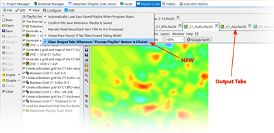
(039) 09/02/21/JPR - New Feature:
An option titled "Clear Output Tabs Whenever "Process Playlist" Button Is Clicked" has been added to the Playlist / Configure pull-down menu. If checked, any open output tabs will be closed before the Playlist processing begins. The result is identical to pressing the "Clear" button before pressing the "Process Playlist" button. The idea is to reduce the clutter left behind by any previous Playlist data processing. The default setting for this new option is "off".
(038) 09/02/21/JPR - Bug Fix:
The "Average" smoothing method for non-lithology modeling menus will no longer be switched to "Classification" after the Lithology Modeling menu has been used.
(037) 09/02/21/JPR - Cosmetic:
The "speed buttons" along the left edge of the Playlist tab sheet now display the icons on the left side of the text versus the icons being positioned above the text. This decreases the likelihood that options won't be visible when the height of the Playlist tab sheet is vertically reduced.

(036) 09/01/21/JPR - Improvement:
The Lithology / 2D Isopach program no longer fits grids to the uppermost and lowermost contacts and subtracts them to produce an isopach grid. Instead, the program simply adds the heights of all voxels that are equal to the designated lithotype to produce the isopach.
(035) 09/01/21/JPR - Bug Fix:
The Peripherals / Color Legend / Title may now be edited if the Title checkbox is checked.
(034) 08/31/21/JCJ - Bug Fix:
P-Data | Histogram by Lithology no longer causes a Access Violation error when there is no Lithology and a Lithology Unit is chosen in the LithoTypes table under diagram options.
(033) 08/27/21/JCJ - Improvement:
File | Export | Stratigraphy, will now export for "All Units" or for a single Stratigraphy Unit/Type.
(032) 08/27/21/JCJ - Bug Fix:
GeoTIFF Import now honors "No Data" data values, converting them to the assigned grid NULL value. This true for the default "No Data" value of -32768 and when the Geo Key Directory of GDAL_NODATA is set.
(031) 08/27/21/JCJ - Bug Fix:
RockWorks will now allow NULL values for the "Collar Elevation". This change will allow the user to not enter a value for this field. Then when RockWorks looks to use the value for Collar Elevation, if it is NULL at that time we would use the Elevation value in its place. This gives the user the ability to set the Collar Elevation to 0.0 if they want and for 0.0 to not behave as if the user did not enter a value. If they set one of the other tables to "measure depths from the Collar" and the Collar is NULL, that borehole would use the Elevation value in its place. The update of the field to nullable now also updates SQL Server databases.
(030) 08/27/21/JCJ - Improvement:
Water level data can be appended to existing data, like T-Data allows. There is a check box on the block mapping tab for Water Levels to allow the user to make the choice to replace or append the data.
(029) 08/25/21/MIW - Bug Fix:
The RockPlot2D Export to RockPlot3D now uses the transparency options for both draped and floating diagrams.
(028) 08/18/21/MIW - Bug Fix:
The Rockplot3D Window will never be opened minimized.
(027) 08/16/21/MIW - Bug Fix:
The Fence Location dialog now updates the map when selecting locations from an XY Pair table.
(026) 08/16/21/MIW - Improvement:
Users can now use the Aquifer Pattern Table colors for water symbols in 2D and 3D Striplogs.
(025) 08/13/21/MIW - Bug Fix:
The Highest Probability solid modeling algorithm now returns the correct values instead of nulls.
(024) 08/13/21/MIW - Bug Fix:
RockWorks no longer starts in the previous project if Select Project on Startup is selected on Preferences menu.
(023) 08/13/21/MIW - Improvement:
Added a program to extract values from a grid based on XY points in a datasheet.
(022) 08/06/21/MIW - New Feature:
Added the ability to extract values from a Solid Model based on XYZ points stored in a datasheet.
(021) 08/06/21/MIW - Improvement:
The Stratigraphy Picker now has the option to snap stratigraphy to an existing lithology contact.
(020) 08/06/21/MIW - New Feature:
Users can now extract values from a solid model along the path of a borehole.
(019) 08/05/21/KD - Upload:
New versions of RockWorks and LogPlot 64/32 bit updated on webpage.
(018) 08/05/21/JCJ - Bug Fix:
State Plane for zones 5200 (Puerto Rico & Virgin Islands - epsg:4437), 1600 (Kentucky Single Zone - epsg:3088) and 5400, 5401 (New Guam Island - epsg:6637) were being translated to the corresponding epsg codes. With Proj 6.2 you cannot override epsg codes with different units, it always uses the units in the epsg definition. I have updated the NAD83 file which RockWorks draws on for State Plane definitions, to the equivalent epsg definition.
(017) 07/26/21/JCJ - Improvement:
Grid Import will import GeoTiff that uses a Geographic CRS (Longitude/Latitude). Also now supports GeoTiffs that use the LZ77 compression scheme.
(016) 07/21/21/MIW - Improvement:
The code used for generating contoured sections and profiles from solid models has been modified to provide much faster performance.
(015) 07/21/21/MIW - Improvement:
Using the Spatial Filter with down hole borehole data now uses the midpoint of the interval as the basis for filtering.
(014) 07/20/21/JCJ - Bug Fix:
When specifying a CRS (Coordinate Reference System) using the Other option, one can specify a pre-defined system (like espg:2229) that has linear units other than international feet or meters (U.S. Surveyors foot for espg:2229). This could introduce inaccurate results for some operations. RockWorks will now warn about this. RockWorks also looks up these units from the definitions for better reporting.
(013) 07/19/21/MIW - Improvement:
An option to use faults for the color fill and contour lines has been added for Profiles, Sections and Projected Sections.
(012) 07/18/21/JPR - Improvement:
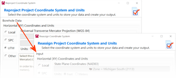
The coordinate system menu now refers to the "Borehole Data" as "Input" to be more inclusive of other data (e.g. GeoTIFF image dimensions).
(011) 07/12/21/MIW - Improvement:
Grid and Solid Metadata is now embedded in Rw3D files and can be viewed from the Info button that's available on the item Options dialog. In addition, the ability to save embedded grids and solids with metadata has been added.
(010) 07/09/21/JCJ - Improvement:
Replaced several TSplitter with TElSplitter controls in the code for a more consistent user experience.
(009) 07/09/21/JCJ - Bug Fix:
Displaying a RW15 grid file will only bring up the conversion dialog once.
(008) 07/09/21/MIW - Bug Fix:
The Borehole Survey program now sets the origin correctly.
(007) 07/08/21/JCJ - Improvement:
Grid Import will import ESRI ASCII Grids that have X and Y dimensions specified to reference the Lower-Left corner of the Lower-Left cell or the center of the Lower-Left cell.
(006) 07/08/21/JCJ - Improvement:
The ModOps | Grid | Grid Math menu now uses the term "Grid" instead of "Model".
(005) 07/07/21/MIW - Improvement:
The Spatial Filtering for Z, Upper Surface and Lower Surface now apply to downhole Borehole labeling for Stratigraphy, Aquifers, I-Data and T-Data.
(004) 07/06/21/JCJ - Bug Fix:
Grid Import - GeoTIFF import: The import now handles both striped and tiled data layouts.
(003) 07/02/21/MIW - Bug Fix:
Users can now select the Manual setting for borehole resolution in the Preferences dialog.
(002) 07/02/21/MIW - Improvement:
The option Include Border has been added to the Billboard map for T-Data, Aquifers (Hydrograph) and Production based billboard displays.
(001) 07/02/21/MIW - Bug Fix:
The Z Filter and Surface Filters in the Spatial Filter are now available when using the Borehole Map function.
NOTE: If you are using a NETWORK license, RockWorks17 v. 2019.9.30 and newer require the RockWare Network License Administrator version 1.09 or newer. Check with your license administrator before installing the RockWorks update. See our forum posting for details.