Search the Community
Showing results for tags 'RockWorks'.
-
We uploaded a new revision of RockWorks16 today, with the following changes: Level 4+ + Color Modeling works properly with declustering and faulting. + Volume and mass calculations are labeled with the project's output units. + Density units can be defined in the Lithology and Stratigraphy Types tables. Level 3+ + Stratigraphy and Lithology Types tables can be exported to the Utilities datasheet. Level 2+ + Block model Grade Statistics by Level now allows you to specify density units. + Grid and solid models can be created from comma-delimited text files. + Run analyses on existing lithology and stratigraphy models (Solid | Statistics menu) + A new Zones program performs the Solid -> Grid functionality for multiple top-base grid regions. It also creates Shapefile output. + New Multiple Polygons -> Grid program assigns grid node values within multiple polygons. + Improvements to the Movement Analysis and Directional Analysis calculation of dip angle. + Improvements to the warping and tilting features within the block modeling programs + The coordinate conversions now work correctly if the coordinate system is the same but the units are different (e.g. feet to meters) + The PicShow AVI Export now allows the user to set the frame-rate (in frames per second) within the output file RockPlot2D + Cross sections with vertical exaggeration > 1 are no longer clipped when exported to a raster format. + Color legends with negative value ranges no longer show a blank color block RockPlot3D + Blocks and surfaces exported from RockPlot3D to Google Earth are now more accurately registered. + Isosurfaces exported from RockPlot3D to Google Earth are no longer flattened. + Items with opacity less than 100% are now exported correctly from RockPlot3D to Google Earth. And more! Check out the Revision List: https://www.rockware.com/rockworks/revisions/current_revisions.htm You can download this build either from within RockWorks itself (Help | Online Information | Check for Updates) or by following these steps: 1. Click on this link: http://www.rockware.com/assets/products/165/product_demo/229/rockworks16_installation.exe 2. Save the file to your local computer (e.g. Downloads folder or Desktop). 3. When the download has completed, you can run the installation. Do not uninstall the existing RockWorks first. 4. When the installation has completed, you can start up the RockWorks16 program. Enjoy! Molly Mayfield RockWare Inc.
-
We've uploaded a new build of RockWorks16 today, with the following improvements: Level 3+ The Other Coords | PLSS Range East/West radio button OnClick Event is now triggered correctly, preventing some coordinate translation errors. Extraneous tab characters in text files being imported via File | Import | Text | Multiple-tables are now ignored. LAS import works when the machine is set to non-US number formats, the LAS file is assumed to be in US/Canadian format for floating point numbers Multiple/Bulk LAS import can now map existing boreholes to the Well Name, API number or UWI number in LAS header When using the Tab Manager, to work with tables and fields, it will open positioned on the same table as the current data sheet. In the ADO import, the dialog to get the Overwrite option (Create New/Skip/Replace) was not moving to the next record when the Skip option was selected. 3D striplog stratigraphy intervals are correctly labeled. Level 2+ Extraneous contours are no longer drawn when a grid is bordered by null values. Pattern editor Preview displays the correct pattern density. 3D points plot properly when you use a lookup table. Level 1+ Location of pattern and symbol files in installation changed to agree with where they are really installed. RockPlot3D export of vertical image panels to Google Earth no longer triggers an error. You can download this build either from within RockWorks itself (Help | Online Information | Check for Updates) or by following these steps: 1. Click on this link: http://www.rockware.com/assets/products/165/product_demo/229/rockworks16_installation.exe 2. Save the file to your local computer (e.g. Downloads folder or Desktop). 3. When the download has completed, you can run the installation. Do not uninstall the existing RockWorks first. 4. When the installation has completed, you can start up the RockWorks16 program. Bon apetit! Molly Mayfield RockWare Inc.
-
We've uploaded a new build of RockWorks16 today, with the following improvements: Level 5 (RockWorks Professional): - Faults Faults Faults! Apply single or multiple, simple or complex faulting to your solid models. This involves defining the fault polyline location(s), dip angle and dip direction in the Utilities datasheet, creating a binary "fault file", then using that with your regular modeling method to restrict data influence across the fault planes. Level 4 (Borehole Modeling) and higher: - Redesigned lithology modeling options window, more consistent with gradational modeling options - P-Data, I-Data, T-Data, Fracture, Color "Surface" maps offer the option to extract from the top, middle, or bottom of the voxel - this prevents blank or spotty maps when using the same extraction surface as was used to constrain the model (e.g. ground surface) - Add external control points to the I-Data, T-Data, P-Data solid modeling process for extra control Level 3 (Borehole Logs and Sections) and higher: - Add "picklists" to your database tables (e.g. lithology details) - Improved handling of raster log images in logs and cross sections - better transparency Level 2 (RockWorks Utilities) and higher: - New Lateral Extrusion modeling method for discrete real number values - like lithoblending for quantitative models - All new solid modeling options window for easier navigation - Create new line-and-symbol maps, great for plan views of horizontal petroleum wells. - Use the new Table-Based Replacement Filter to replace discrete values in a solid model (e.g. lithology) with other values (e.g. hydraulic conductivity) - Use the new Faults menu tools to create: + 3D oriented "ribbon" displays + binary "fault" files which can be used to apply faulting to borehole-based solid models + Boolean fault models for a block model view of the fault plane locations - Solid model resampling offers a closest-point method for lithology and stratigraphy solids Level 1 (EarthApps, Plot windows) and higher: - A new "RockWorks15 to RockWorks16" converter program is now installed with RockWorks16, for batch updating of ATD, RK6, R3DXML, GRD, and MOD files to the new formats - Improvements to the Rockplot3D video exports Oh, and we've fixed a few bugs, too... You can download this build either from within RockWorks itself (Help | Online Information | Check for Updates) or by following these steps: 1. Click on this link: http://www.rockware.com/assets/products/165/product_demo/229/rockworks16_installation.exe 2. Save the file to your local computer (e.g. Downloads folder or Desktop). 3. When the download has completed, you can run the installation. Do not uninstall the existing RockWorks first. 4. When the installation has completed, you can start up the RockWorks16 program. Enjoy! Molly Mayfield RockWare Inc.
-
While we don't like to post new builds on Friday (as we go into the weekend) we made an exception today because this build fixes some important items: + RockPlot3D: no more Access Violation when right-clicking on an item in the data tree. + Borehole Manager: Fix to Access Violation on new Value List fields which you can add to Lithology, Stratigraphy, other data tables. + Borehole Manager: Export to Excel, on systems set up to Swedish number format ("123 456 789,00") AND where there are > 2 decimal places - changed the way the numbers are exported so that Excel does not incorrectly understand them. + Utilities: Export to Excel - changed the way numbers are exported so that Excel does not incorrectly understand them on systems not using a US number format. + Added a Set Entry Defaults button on the Other Coords tab (Location table) where you can set up the default coordinate zones/meridians/etc. for hand-entered data. + Problems in the solid model smoothing (this was fixed in the 5.28 build) You can download this build either from within RockWorks itself (Help | Online Information | Check for Updates) or by following these steps: 1. Click on this link: http://www.rockware.com/assets/products/165/product_demo/229/rockworks16_installation.exe 2. Save the file to your local computer (e.g. Downloads folder or Desktop). 3. When the download has completed, you can run the installation. Do not uninstall the existing RockWorks first. 4. When the installation has completed, you can start up the RockWorks16 program. Molly Mayfield RockWare Inc.
-
The most recent public build of RockWorks16 (2014.5.20) has a known issue with the Smoothing option in gradational (I-Data, P-Data, T-Data) solid models. You'll need to turn off smoothing when generating new models. Or, if you prefer you can download a previous public build please contact tech support and we can arrange for a download. Molly Mayfield RockWare Inc.
-
In RockWorks16 we've added new "smarts" to the program for data sets with lots of missing stratigraphic data, such as historic data which can be downloaded from commercial and state sources. This topic addresses the "insert missing units" rule. This rule is displayed in the Rules and Filters pane along the right side of many of the RockWorks program menus. The Insert Missing Units rule was added to the program for situations like this, in which formations have pinched out and are not present in a borehole: HOLE-A HOLE-B Fm_A 0 20 Fm_B 0 25 Fm_D 20 30 Fm_C 25 35 Fm_G 30 50 Fm_G 35 50 If the Insert Missing Units rule is on, then it does NOT add missing formations to the database, but WILL determine the location for the unit as it passes points to the modeling routine. For example, it will include a point for FmB in Hole-A at depth of 20 (the elevation represented there), even though it will not add the unit to the Stratigraphy data table. However, if you have already added the missing formations to the database, manually or via the Striplogs | Insert Missing Stratigraphy program, and your data looks like this: HOLE-A HOLE-B Fm_A 0 20 Fm_A 0 0 Fm_B 20 20 Fm_B 0 25 Fm_C 20 20 Fm_C 25 35 Fm_D 20 30 Fm_D 35 35 Fm_E 30 30 Fm_E 35 35 Fm_F 30 30 Fm_F 35 35 Fm_G 30 50 Fm_G 35 50 Then turning on the Insert Missing Units rule may cause duplicate tops. This is most pronounced when you have multiple sequential zero-thickness units. It is probably best to choose which strategy to use for missing (pinchout) formations and do this throughout the project - either omit them from the database and have the Insert Missing Units rule insert them on the fly, or insert them manually and turn off the Insert Missing Units rule. More details and examples about the strat rules are in the help messages. There's also a recording of a webinar addressing pinchouts on our website and on Rockware's YouTube channel. Molly Mayfield Rockware Inc.
-
We've uploaded a new build of RockWorks16 today, with the following changes: RockWorks Professional (Level 5) + RockWorks can accommodate MDB project databases that lie outside the project folder. RockWorks Borehole Modeling (Level 4) and higher + Polygon filters have been added to the lithology modeling options. + Polygon filters and upper/lower surface filters are applied during rather than after lithology modeling, making the process faster. + Grid surfaces with null values can be used to warp lithology models. (This example is warped with a faulted surface.) RockWorks Logs & Sections (Level 3) and higher + Improved memory management for handling raster images in 2D striplogs + Improved LAS import options for assigning/mapping well name to the database + More transparency options for raster images in 2D striplogs RockWorks Utilities (Level 2) and higher + The size of solid models that may be viewed within RockPlot3D without generating an out-of-memory error has been increased. + More options for smoothing solid (block) models: most-common-value in addition to averaging; tools for opting out "sacrosanct" nodes; more smoothing passes. These allow for effective grouping of fine lithology zones. RockWorks EarthApps (Level 1) and higher + The scaling for RockPlot3D to Google Earth exports now adjust for dimension changes over large areas at different latitudes (i.e. x and y are scaled independently). For a complete list of revisions, please visit: https://www.rockware.com/rockworks/revisions/rw16_current_revisions.htm To download the latest version of RockWorks16, please follow these steps: 1. Click on this link: https://www.rockware.com/assets/products/165/product_demo/229/rockworks16_installation.exe 2. Save the file to your local computer (e.g. Downloads folder or Desktop). 3. When the download has completed, you can run the installation. Do not uninstall the existing RockWorks first. 4. When the installation has completed, you can start up the RockWorks16 program. Molly Mayfield RockWare Inc.
-
A Rockworks16 user recently submitted an email inquiry to our tech staff: I am creating a series of lith sections that include a single I-Data column. All is well and I have a layout that works well. I am saving an RCL for each section and while it saves the layout parameters, text details etc it is not saving the line of the section on the map. IS that expected or must I load the saved RCL then re-pick the line of section? RCL scripts do not actually save the section location you've drawn in the Section Selection Map tab. Instead, you can save each section location to the database using the File | Export | Database Table menu option at the top of the Section Selection Map window, assigning a name of your choice. This will now be saved in your database for future re-loading into that map display (File | Import) or for use in an RCL script: DEFINE: TABLES XY_TABLE North to South DEFINE: GENERAL 2D_OUTPUT N-S.rw2d EXECUTE: LITH_SECTION Profile and fence locations can similarly be saved in the Selection Map window to the database, and then re-loaded into the Selection Map window or called via RCL. These are all accessible via the Project Manager | Project Tables | Log/Section Tables: "XY Coordinate Tables" for sections, "XY Pair Tables" for fences, and "Profile Tables" for profiles. Note that you can also draw your section paths in a Rockplot2D map (say, of your borehole locations) using the Draw | Line Types | Polyline drawing tool. When the polyline is complete you can right-click on it and choose Save to XY (Polyline) Table, assigning a name of your choice, and this series of coordinate pairs will be stored in the database, just as above. Then repeat for any other cross sections you'll want to create. Molly Mayfield RockWare Inc.

-
We've uploaded a new build of RockWorks16 today, with the following changes: RockWorks Professional (Level 5) + The RCL version of the ADO import of data into the Borehole manager has been updated to work for RW16 RockWorks Logs and Sections (Level 3) and higher + Much faster transfer of RockWorks15 projects to RockWorks16, particularly if you have a lot of Point data. (Hours to minutes) + The Section Selection Map now highlights the nearest borehole with a green (color will change depending on the background) rectangle if Snap is activated RockWorks Utilities (Level 2) and higher + The Filter-based Grid Resampling now includes an option for dealing with destination-grid nodes that reside outside the source grid - they can be interpolated, set to Null, or to a user-defined value. + Grid resampling has better handling of grid edges. + Improved Grid | Mosaic program. + Fixed a problem with non-US date formats in the Grid | Statistics | Report and Solid | Statistics | Report programs. RockWorks EarthApps (Level 1) and higher + The installation security certificate is now correctly time-stamped. + RockWorks projects can be initialized with local coordinates, where map coordinates and vertical units are in feet. For a complete list of revisions, please visit: http://www.rockware.com/rockworks/revisions/rw16_current_revisions.htm To download the latest version of RockWorks16, please follow these steps: 1. Click on this link: http://www.rockware.com/assets/products/165/product_demo/229/rockworks16_installation.exe 2. Save the file to your local computer (e.g. Downloads folder or Desktop). 3. When the download has completed, you can run the installation. Do not uninstall the existing RockWorks first. 4. When the installation has completed, you can start up the RockWorks16 program. Molly Mayfield RockWare Inc.
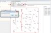
-
We forgot to post this detailed list of changes from April 9th! Here's a quick summary of the new features of the 2014.4.9 version of RockWorks16; for the detailed revisions list (all changes and fixes) please visit: http://www.rockware.com/rockworks/revisions/rw16_current_revisions.htm RockWorks Professional (Level 5) + Import commercial land grid data - create custom PLSS libraries in addition to the built-in RockWorks Landbase. RockWorks Borehole Modeling (Level 4) and higher + List strike and dip with your stratigraphic contacts, and use the new dip-gridding algorithm to interpolate structural surfaces. RockWorks Logs and Sections (Level 3) and higher + Expanded Bitmaps table in the Borehole Manager - define different Bitmap Types, to maintain multiple images for each borehole. + More options for raster images in striplogs - choose Bitmap Type, preserve aspect ratio, in both 2D and 3D logs. + Query the database on Aquifer name, sampling date, Bitmap type; other database query improvements. + Improved Excel export from the Borehole Manager. + Clean up noisy borehole survey measurements common from automated collection tools. RockWorks Utilities (Level 2) and higher + Create structural surfaces from orientation data (XYZ, dip-direction, dip-angle data) using "dip-gridding" algorithm. + Display dip data (e.g. points along a fault, contact, bedding plane) as "dip ribbons" (single and multiple). + Create well production diagrams in both 2D and 3D. RockWorks EarthApps (Level 1) and higher + Use the new Row Editor when collecting data in the field on your tablet. + Use linked "pick lists" for field data collection. + Enable/disable the automatic Google Earth elevation offset (see the dip ribbons above). + Add titles to RockPlot3D scenes, including lists for morphed scenes. + Add logos to your RockPlot3d scenes. + Choose recent projects from the main program window. To download the latest version of RockWorks16, please follow these steps: 1. Click on this link: http://www.rockware.com/assets/products/165/product_demo/229/rockworks16_installation.exe 2. Save the file to your local computer (e.g. Downloads folder or Desktop). 3. When the download has completed, you can run the installation. Do not uninstall the existing RockWorks first. 4. When the installation has completed, you can start up the RockWorks16 program. Molly Mayfield RockWare Inc.
-
 If you are working with RockWorks16, Level 5, and a SQL Server database, you may see this error if you are using one of the Borehole Manager query tools (View | Filter Boreholes or View | Select Boreholes), applying a Polygon Region query, AND your borehole names contain a "#" character (such as DH #1). The next public upload of the program will contain a fix for this. It has to do with the different characters that Access and SQL use to mark date fields, and we were filtering out the "#" characters which in turn mucks up the borehole names. In the meantime you'll need to perform the query with a rectilinear or circular region (which function differently), or remove the "#" characters from your borehole names. Molly Mayfield RockWare Inc.
 -
The RW16 installation program sets up file associations and file icons for: Rw2D, Rw3D, RwDat and RwRpt file extensions - so you can double-click on one of these file types in Windows Explorer, and Windows will know what program to use to open it. However it is possible for these settings to change even though the correct registry settings haven't been touched. To fix the file type - program associations is pretty straight forward: go to the Control Panel/Default Programs/Set Associations. Select the file extension and click change program. However this won't fix the file icons. For this you need to do some Registry Surgery. Go to HKEY_CURRENT_USER\Software\Microsoft\Windows\CurrentVersion\Explorer\FileExts and find the File Extension key you want to fix (such as .Rw2D) and delete it. When you reboot your computer the correct file icon will be restored. The file associations allow you to select and open multiple files from Windows Explorer using only 1 instance of RockWorks16. Of course doing multiple RwDat files doesn't do much since there's only 1 viewer. (Thanks, Mitch, for the handy tips.) Molly Mayfield RockWare Inc.
-
We've uploaded a new build of RockWorks16 to our website, with many new features, fixes, and improvements - here are a few: Level 4 and higher - New Projected Section program added to Lithology, Stratigraphy, P-Data, T-Data, I-Data, Aquifers, Fractures, and Colors menus - huge benefit for geotechnical projects with many boreholes and long section traces - New tools for modeling only selected stratigraphic units - huge benefit for deep project areas where you want to focus on specific strata - Improvements to all of the Profile menus for creating automatic parallel profiles as a single output diagram - Improvements to modeling stratigraphic data referenced to collar elevations rather than ground elevations Level 3 and higher - New Projected Section program added to Striplogs | 2-Dimensional menu - huge benefit for geotechnical projects with many boreholes and long section traces - New options for correlating logs either axis-to-axis or edge-to-edge both in section diagrams and in the Stratigraphy Picker - New options for handling downhole survey data with a variety of formats (vertical = -90 or 0 or +90) - New options for plotting inclined and deviated well paths in Borehole Locations -> Google Earth maps - New options for including Bitmaps table images (e.g. raster logs, core logs) as reference description data in Borehole Locations -> Google Earth maps - New Bitmap Types table enables multiple raster images to be stored for specific depth ranges - Improvements to all of the Striplogs | 2D | Profile menu for creating automatic parallel profiles as a single output diagram - Improved memory management for handling of larger P-Data, I-Data, and T-Data datasets - Improvements to the Excel and Text exports from the Borehole Manager - Improvements to the Grids -> Stratigraphic Logs program - Enhanced LAS imports - much faster - Fixed and enhanced the plotting of logs in Strip Logs, Sections, Projected Sections, Profiles and Fences when using Collar Elevations Level 2 and higher - Display background images in the section, profile, projected section, and fence selection windows - Support of both Strike (right-hand rule) and Dip Direction data in the Fracture Disks -> Solid, Planes | Strike & Dip Diagram, and Planes | Strike & Dip Map programs - New options for handling null values added to the Grid & Grid Math menu - Improvements to the solid model declustering logic Level 1 and higher - Disable automatic above-ground offset for objects output to Google Earth - handy for items which you want to plot at their actual elevations in relation to the ground (e.g. fault ribbons, etc.) - Improvements to the tree menus used throughout the program - easier controls For a complete list of the latest changes, please refer to our revisions list: http://www.rockware.com/rockworks/revisions/rw16_current_revisions.htm To download the latest version of RockWorks16, please follow these steps: 1. Click on this link: http://www.rockware.com/assets/products/165/product_demo/229/rockworks16_installation.exe 2. Save the file to your local computer (e.g. Downloads folder or Desktop). 3. When the download has completed, you can run the installation. Do not uninstall the existing RockWorks first. 4. When the installation has completed, you can start up the RockWorks16 program. Enjoy! Molly Mayfield RockWare Inc.
-
The RockWare GIS Link 16 program is a toolbar that installs into ArcMap and provides a link between ArcMap and RockWorks16. It is required that both ArcGIS and RockWorks be installed before installing the GIS Link. If you don't have ArcGIS installed on your computer, you may see this error message when trying to install the RockWare GIS Link 16 program. Molly Mayfield RockWare Inc.
-
We are excited to announce that the RockWare GIS Link 16 is now available! Install this toolbar into ArcMap and use its tools to: + Import your RockWorks borehole locations into ArcGIS + Pick striplog/cross section/profile/fence diagram locations in ArcMap for diagram display in RockWorks + Create structural or isopach contours for display in ArcMap The RockWare GIS Link 16 requires RockWorks 16 Level 3 (with limited functionality), Level 4, or Level 5. It also requires ArcGIS Desktop 10+. RockWare GIS Link 16 can be activated automatically with RockWorks 16 Level 5 licenses: If you already have RockWorks 16 Level 5 installed and running, just download and install the GIS Link demo, add the toolbar to ArcMap, and no further licensing is required. (For lower levels of RockWorks, the GIS Link licenses are purchased separately.) More information: http://www.rockware.com/product/overview.php?id=166 Download demo: http://www.rockware.com/product/productDemo.php?id=166 RockWare, Inc. www.rockware.com
-
We've uploaded a new build of RockWorks16 to our website, with many new features, fixes, and improvements - here are a few: Level 4 and higher - NEW: The Network License Manager now offers "borrowing" of licenses for use in the field. (This requires installation of the latest version of RockWorks AND the latest version of the license manager. Contact support for more information). - NEW: T-Data Time-Graph and Time-Graph Map programs now allow the user to specify a logarithmic scale - NEW: T-Data Time-Graph and Time-Graph Map programs now allows the user to manually specify the Minimum and Maximum values for the chart, for scaling consistency on the maps - Improvement: It is no longer necessary to disable boreholes that have no stratigraphy data when performing stratigraphic operations in the Borehole Manager. Level 3 and higher - NEW: The Borehole Locations -> Google Earth maps have been relocated back to the Map menu (from the Export menu). It is now offered with Simple and Advanced options. - NEW: Images in the Bitmaps table in the borehole database can be included in the pop-up description in the Borehole Location -> Google Earth maps. - NEW: Optional locaton fields can be included in the pop-up description in the Borehole Location -> Google Earth maps. - Improvement: You can disable the display of the borehole locations in the query programs (View | Filter Boreholes and Select Boreholes) which can speed things up for huge datasets. - Improvement: any problem records during import of KGS, IHS, WCS, and GDS data will just be skipped rather than halting the import. - Fixed a problem with the elevation values when Include XYZ Computations is requested in the multi-table Excel export Level 2 and higher - Fixed a problem with the Utilities | Volumetrics | 2D (Grid Model) plotting reports and maps. Level 1 and higher - NEW: Several new symbols were added to the raster symbol library used in Google Earth maps. - Improvement: The RockPlot3D DXF export now has an option to view the resulting file within your default DXF viewing program. For a complete list of the latest changes, please refer to our revisions list: http://www.rockware.com/rockworks/revisions/rw16_current_revisions.htm To download the latest version of RockWorks16, please follow these steps: 1. Click on this link: http://www.rockware.com/assets/products/165/product_demo/229/rockworks16_installation.exe 2. Save the file to your local computer (e.g. Downloads folder or Desktop). 3. When the download has completed, you can run the installation. Do not uninstall the existing RockWorks first. 4. When the installation has completed, you can start up the RockWorks16 program. Enjoy! Molly Mayfield RockWare Inc.
-
We've uploaded a new build of RockWorks16 to our website, with the following new features, fixes, and improvements: Level 5 - When reading floating point numbers in RCL files RockWorks falls back to the computers regional format setting if the US format conversion fails. Level 4 and higher - Spatial filters were removed from the Lithology Volumetrics. Level 2 and higher - New: LAS files can now be imported directly into the Utilities data sheet. - New: You can enable text anti aliasing in RockPlot2D graphics (on by default) via the RockPlot2D tab of the General Preferences. Anti aliasing smooths the appearance of text on the screen and in raster exports but can make very small text appear fuzzy. With anti aliasing disabled small text may appear pixelated. This also works for RockPlot2D files displayed in ReportWorks. - The Grid Editor menu items now work correctly. - The Grid Editor Statistics report is now created and displayed. - Fast Inverse Distance was not using the user specified number of points per borehole for Solid Modeling. - Labels in Section Maps are no longer set to a 0 size font. - Determined a workaround for Windows Vista for finding the correct text extents in RockPlot2D. - Fixed a Range Check error for RockPlot3D Triangles when there was only 1 triangle in the list. Level 1 and higher - The current Vertical Exaggeration in RockPlot3D is now stored in the file and set upon loading. - ReportWorks can now plot very high resolution pages with full color output. - In RockPlot3D users were unable to tear off a scene after appending a file. - Fixed Invalid Floating Point error when using the Zoom combobox in RockPlot2D when no scrollbars were visible. - Failed exports of raster images from ReportWorks now generates a relevant error message. To download the latest version of RockWorks16, follow these steps: 1. Click on this link: http://www.rockware.com/assets/products/165/product_demo/229/rockworks16_installation.exe 2. Save the file to your local computer (e.g. Downloads folder or Desktop). 3. When the download has completed, you can run the installation. Do not uninstall the existing RockWorks first. 4. When the installation has completed, you can start up the RockWorks16 program. Bon apetit! Molly Mayfield RockWare Inc.
-
On Thursday October 17th, we uploaded a new build of RockWorks16 to our website, with more new features and improvements, including: + 33 new "major" datums have been added to the program, with improvements to how the parameters are displayed and new custom datum definitions. + New Lateral GeoSteering Diagram has been added to the Utilities | Survey menu. + New Lateral 3D GeoSteering Comparison program has been added to the Utilities | Survey menu. + New programs for computing an optimum well path based on known XYZ points have been added to the Utilities | Survey menu. (We've posted a YouTube video on this, too.) See: http://www.rockware.com/product/featuresLobby.php?id=165&category=1024 + New tools for exporting draped and vertical raster images from RockPlot3D to Google Earth, with support of transparent colors. + New program for connecting polygons in 3D (Utilities | Grafix | 3D Utilities) + Improved handling of datasheet units (defined and not-defined) when processing values in the Utilities programs. + Improved coordinate conversion handling in the text and Excel imports. + Improvements to clipping raster images in RockPlot2D. + Plot Lithology, Stratigraphy, or Aquifer legends in Utilities | Solid | Mode. + Fixed text/symbol angles in annotated polylines when the vertical exaggeration is not 1.0. + Edit as Datasheet works properly - posting values back to the database - when no data yet exists for that hole. + Fixed some coordinate problems in RockPlot3D when exporting to Google Earth. + Much more For a complete list of recent changes, please visit our revisions list: http://www.rockware.com/rockworks/revisions/rw16_current_revisions.htm For highlights of what's new in RockWorks16 (since RockWorks15) please see: http://www.rockware.com/product/newFeaturesContent.php?id=165 To download the latest version of RockWorks16, follow these steps: 1. Click on this link: http://www.rockware.com/assets/products/165/product_demo/229/rockworks16_installation.exe 2. Save the file to your local computer (e.g. Downloads folder or Desktop). 3. When the download has completed, you can run the installation. Do not uninstall the existing RockWorks first. 4. When the installation has completed, you can start up the RockWorks16 program. Enjoy! Molly Mayfield RockWare Inc.
-
We've uploaded a new build of RockWorks16 to our website, with more new features and improvements, including: + New options for display of keywords and comments in 3D striplogs + Expanded Unicode (non-latin) font support in barchart, piechart, spider, and starburst maps + New transparent color and opacity settings for 2D striplog raster images for improved cross section displays + New option to pre-grid points for display in the interactive variogram editor (offered when kriging is selected as the gridding method) which improves the variograms for small data sets + The Fill In Missing Stratigraphy program has been moved to the Striplogs menu to be more consistent with Level-3 functionality + Improved layer renaming in ReportWorks and RockPlot2D + Improved the palette-method of building a custom color table - better color gradations and ascending or descending order + Improved the way the output dimensions are calculated using the Scan Boreholes button + Fixed a bug with striplog cross sections being placed at collar elevations rather than ground elevations + Much more For a complete list of recent changes, please visit our revisions list: http://www.rockware.com/rockworks/revisions/rw16_current_revisions.htm For highlights of what's new in RockWorks16 (since RockWorks15) please see: http://www.rockware.com/product/newFeaturesContent.php?id=165&category=326 To download the latest version of RockWorks16, follow these steps: 1. Click on this link: http://www.rockware.com/assets/products/165/product_demo/229/rockworks16_installation.exe 2. Save the file to your local computer (e.g. Downloads folder or Desktop). 3. When the download has completed, you can run the installation. Do not uninstall the existing RockWorks first. 4. When the installation has completed, you can start up the RockWorks16 program. Enjoy! Molly Mayfield RockWare Inc.
-
We've uploaded a new build of RockWorks16 to our website, with more improvements and bug fixes, including: + An all-new Preferences | General Program Settings window for much greater clarity. + A new Visible Features option in the General Program Settings allows you to customize which menus are displayed, individually or in groups. + The Lithology | Superface and Subface programs, which allow you to generate surfaces for material tops or bases, can create new lithology models, as well as read existing ones. + The following programs have been moved from their respective menus to the Striplogs menu to be more consistent with Level-3 functionality: Stratigraphy | Consolidate Stratigraphy | Pick Stratigraphic Contacts Lithology | Consolidate Lithology | Pick Lithologic Contacts + Improvements to the editing and display options in the grid editor and solid model editor. + The recent update of Google Earth with a fix to textures allowed us to remove a complicated work-around. + Added a work-around for a Windows error that was sometimes displayed when removable media (CDs, memory cards, etc.) had been removed from the system. + Lots more (36 other entries, to be exact). For a complete list of recent changes, please visit our revisions list: http://www.rockware.com/rockworks/revisions/rw16_current_revisions.htm For highlights of what's new in RockWorks16 (since RockWorks15) please see: http://www.rockware.com/product/newFeaturesContent.php?id=165&category=326 To download the latest version of RockWorks16, please follow these steps: 1. Click on this link: http://www.rockware.com/assets/products/165/product_demo/229/rockworks16_installation.exe 2. Save the file to your local computer (e.g. Downloads folder or Desktop). 3. When the download has completed, you can run the installation. Do not uninstall the existing RockWorks first. 4. When the installation has completed, you can start up the RockWorks16 program. (You can turn on/off automatic notification of program updates in the RockWorks Preferences | General Program Settings | Updates settings.) Molly Mayfield RockWare Inc.
-
We've posted a new build of RockWorks 15 (2013.8.9) to our website, with the following fix: + A cutout in a 3D isosurface now honors its on/off checkbox. To download the latest version of RockWorks15, please follow these steps: 1. Click on this link: (outdated link removed) 2. Save the file to your local computer (e.g. desktop). 3. When the download has completed, you can run the installation. Do not uninstall RockWorks first, if it already exists on your computer. 4. When the installation has completed, you can start up the RockWorks15 program. Molly Mayfield RockWare Inc
-
We've uploaded a new build of RockWorks16 to our website, with more improvements and bug fixes, including: > Added a "Create File List" option to the EarthApps/Utilities File | Import menu, to populate the datasheet with a list of file names of a specified file type which reside in the current project folder. Handy for building a grid list, image list, etc. quickly > Added a link to the RockWorks video lists in the Help | Online Information menu, and all of the Intro menus in the program > Fixed some issues with contour lines drawn for polygon-clipped grid models > Fixed some issues with the Multiple Points Coordinate Converter > Fixed some issues with layering and selecting items in Rockplot2D > Fixed some issues with the RockPlot3D Morph Model program > Fixed some issues with the I-Data Resampling > Fixed some issues with RCL scripting For a complete list of recent changes, please visit our revisions list: http://www.rockware.com/rockworks/revisions/rw16_current_revisions.htm For highlights of what's new in RockWorks16 (since RockWorks15) please see: http://www.rockware.com/product/newFeaturesContent.php?id=165&category=326 To download the latest version of RockWorks16, please follow these steps: 1. Click on this link: http://www.rockware.com/assets/products/165/product_demo/229/rockworks16_installation.exe 2. Save the file to your local computer (e.g. Downloads folder or Desktop). 3. When the download has completed, you can run the installation. Do not uninstall the existing RockWorks first. 4. When the installation has completed, you can start up the RockWorks16 program. (You can turn on/off automatic notification of program updates in the RockWorks Preferences | General Program Settings | On Startup menu.) Molly Mayfield RockWare Inc.
-
We've uploaded a new build of RockWorks16 to our website, with more improvements and bug fixes, including: > Some slight changes to the Samples database. > Improvement to the program licensing. > New features in the Solid | Math and Grid | Math programs. > Modifications to the Grid and Solid | Statistics reports. > Improvements to the scaling of the horizontal axis in all program frequency histograms. > Improvements to the axis labels in Time Graphs and Time Graph Maps For a complete list of recent changes, please visit our revisions list: http://www.rockware.com/rockworks/revisions/rw16_current_revisions.htm For highlights of what's new in RockWorks16 (since RockWorks15) please see: http://www.rockware.com/product/newFeaturesContent.php?id=165&category=326 To download the latest version of RockWorks16, please follow these steps: 1. Click on this link: http://www.rockware.com/assets/products/165/product_demo/229/rockworks16_installation.exe 2. Save the file to your local computer (e.g. Downloads folder or Desktop). 3. When the download has completed, you can run the installation. Do not uninstall the existing RockWorks first. 4. When the installation has completed, you can start up the RockWorks16 program. (You can turn on/off automatic notification of program updates in the RockWorks Preferences | General Program Settings | On Startup menu.) Molly Mayfield RockWare Inc.
-
We've uploaded a new build of RockWorks16 to our website, with more improvements and bug fixes. For a complete list of recent changes, please visit our revisions list: http://www.rockware.com/rockworks/revisions/rw16_current_revisions.htm For highlights of what's new in RockWorks16 (since RockWorks15) please see: http://www.rockware.com/product/newFeaturesContent.php?id=165&category=326 To download the latest version of RockWorks16, please follow these steps: 1. Click on this link: http://www.rockware.com/assets/products/165/product_demo/229/rockworks16_installation.exe 2. Save the file to your local computer (e.g. Downloads folder or Desktop). 3. When the download has completed, you can run the installation. Do not uninstall the existing RockWorks first. 4. When the installation has completed, you can start up the RockWorks16 program. Molly Mayfield RockWare Inc.
-
We've uploaded a new build of RockWorks16 to our website, with more improvements and bug fixes. For a complete list of recent changes, please visit our revisions list: http://www.rockware.com/rockworks/revisions/rw16_current_revisions.htm For highlights of what's new in RockWorks16 (since RockWorks15) please see: http://www.rockware.com/product/newFeaturesContent.php?id=165 To download the latest version of RockWorks16, please follow these steps: 1. Click on this link: http://www.rockware.com/assets/products/165/product_demo/229/rockworks16_installation.exe 2. Save the file to your local computer (e.g. Downloads folder or Desktop). 3. When the download has completed, you can run the installation. Do not uninstall the existing RockWorks first. 4. When the installation has completed, you can start up the RockWorks16 program. Molly Mayfield RockWare Inc.


