Featured products
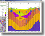
WellCAD
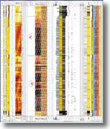 WellCAD's
Basic Module incorporates all features and tools
necessary to import, edit, process and display your
Well data. A number of additional modules are also
available: WellCAD's
Basic Module incorporates all features and tools
necessary to import, edit, process and display your
Well data. A number of additional modules are also
available:
CoreCAD: interactive digital core description
Deviation: Well path visualization tool.
Borehole Image Analysis: display and
interpretation tools.
Sonic Processing: Import, pre-processing, dt
picking and more.
Read more
Download demo
WellCAD pricing
RockWare GIS Link v2
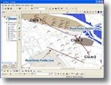 Install
the RockWare GIS Link toolbar into ArcMap and
import your RockWorks borehole locations.
Create RockWorks cross sections, profiles,
fence diagrams, striplogs, structure and isopach
maps right from ArcView. Install
the RockWare GIS Link toolbar into ArcMap and
import your RockWorks borehole locations.
Create RockWorks cross sections, profiles,
fence diagrams, striplogs, structure and isopach
maps right from ArcView.
Read more
Download demo
RockWare GIS Link pricing
AQTESOLV
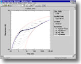 AQTESOLV
for Windows features a comprehensive suite of
analytical solutions for evaluating pumping test and
slug test data in confined, unconfined, leaky and
fractured aquifers. AQTESOLV
for Windows features a comprehensive suite of
analytical solutions for evaluating pumping test and
slug test data in confined, unconfined, leaky and
fractured aquifers.
AQTESOLV pioneered the integrated use of
visual and automatic curve-matching methods for the
analysis of aquifer test data. No other program
provides greater ease or flexibility in evaluating
data from pumping tests, slug tests or constant-head
tests.
Standard and Pro versions are available.
Read more
Download demo
AQTESOLV pricing
Back to top

New Versions
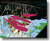
SpheriStat 3.0
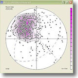 SpheriStat
3.0 for Windows is an integrated, powerful and
easy-to-use analytical tool for making stereonets,
structural maps and rose diagrams, with lots of
display, printout and export options. Some of
the new features include: SpheriStat
3.0 for Windows is an integrated, powerful and
easy-to-use analytical tool for making stereonets,
structural maps and rose diagrams, with lots of
display, printout and export options. Some of
the new features include:
* Runs in Vista and Windows 7.
* User-created map and net symbols.
* Dataset size limited only by available computer
memory.
* Added output options for analyses.
* Colored map and circular diagram symbols.
* Display of planar data as pole trend and plunge.
Read more
Download demo
SpheriStat pricing
Hydro GeoAnalyst 2009.1
Hydro GeoAnalyst 2009.1 is full of added
functionality and enhancements, delivering
functionality unavailable with other commercial
software - all within a single, flexible desktop
solution.
From interpretation and analysis of groundwater and
borehole data, to advanced 3D visualization and
reporting, professionals like you can:
* Manage and report vast amounts of data for
municipal, state, & national groundwater monitoring
programs
* Manage various data types collected at remediation
sites (soil and groundwater samples, hydrogeologic
profiles, etc.)
* Store historic and current project data in a
single data management system
* Analyze the relationship between subsurface
geology, contaminant plumes, and risks to land use
policy
* Assess borehole data acquired for mineral
exploration
* Prepare data for use in groundwater models such as
Visual MODFLOW
* Produce monthly, quarterly, or annual reports
mandated by regulators
Read more
Hydro GeoAnalyst pricing
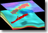
Encom Discover 11.1 &
Discover 3D 5.0.63
 With
its extensive range of features customized for
geoscience applications, Discover unlocks the
power of MapInfo Professional for geologists
and other geoscience professionals. Bug fixes
and performance improvements include: With
its extensive range of features customized for
geoscience applications, Discover unlocks the
power of MapInfo Professional for geologists
and other geoscience professionals. Bug fixes
and performance improvements include:
* Discover 11.1: hydrology toolset, grid
handlers and grid handler performance.
Supports Windows 7
* Discover 3D 5.063: 3D rendering, DXF and
vector file import, toolbar and selection
* Licensing: improvements to menus on server
deployments
Encom Discover and Discover 3D updates are available
from the
developer.
Read more
Get a quote
Back to top
TIPS
RockWorks15: 3D Image Tools
Use
RockWorks15 to display images in 3D:
Float an image at a fixed elevation:
Drape an image over a surface:
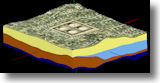
Display images as horizontal panels:
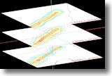
Display images as vertical panels:
and more.
Read more
Download demo
RockWorks15 pricing
Back to top
|