NEW VERSIONS
Global Mapper 11
 A
new version of one of our most popular products!
Global Mapper 11 continues the tradition of
easy import, display, and manipulation of a huge
variety of GIS data. Use Global Mapper
to access the entire TerraServer database of USGS
satellite imagery and topographic maps free of
charge and to view elevation data in true 3D with
any loaded raster imagery and vector data.
Global Mapper 11 exports to RockWorks
formats, making it a wonderful companion to the
modeling tools there. A
new version of one of our most popular products!
Global Mapper 11 continues the tradition of
easy import, display, and manipulation of a huge
variety of GIS data. Use Global Mapper
to access the entire TerraServer database of USGS
satellite imagery and topographic maps free of
charge and to view elevation data in true 3D with
any loaded raster imagery and vector data.
Global Mapper 11 exports to RockWorks
formats, making it a wonderful companion to the
modeling tools there.
* Native 64-bit version - work with much larger data sets in 64-bit versions of Windows.
* Import/export GeoPDF files!
* Add margins, north arrows to maps, adjust legends.
* Export loaded vector data to DWG.
* Access updated DigitalGlobe imagery for expanded worldwide coverage.
* Access free global street-level maps
from OpenStreetMap.org.
* Export multi-band GeoTIFF files.
* Display current cursor information (location, distance, elevation) in 3D Path Profile dialog.
* Create symbols from common shapes like dots, squares, diamonds, and stars.
* Add custom point symbols from PNG, GIF, and JPG images with support for translucent symbols.
* Add custom point symbols from vector format files.
* and much more
Read more
Global Mapper 11 pricing
Discover 3D v5
 With
its extensive range of features customized for
geology-related applications, Encom Discover
unlocks the power of MapInfo Professional for
geoscience professionals. The Encom Discover 3D
Module turns 2D GIS into a full 3D system; its
latest release provides new modeling functionality,
interface improvements, and more: With
its extensive range of features customized for
geology-related applications, Encom Discover
unlocks the power of MapInfo Professional for
geoscience professionals. The Encom Discover 3D
Module turns 2D GIS into a full 3D system; its
latest release provides new modeling functionality,
interface improvements, and more:
* Interpolate your digitized objects into gridded
surfaces.
* Generate solids from triangulated surfaces.
* Utilize the new, advanced solid editing
capabilities.
* Take advantage of dockable panels and editable workspace tree for increased efficiency.
Read
more
Encom Discover pricing
Back to top

FEATURED products
RockWorks Utilities
RockWorks Utilities is an indispensible
collection of mapping, modeling, analysis, and
display tools.
* Create point maps, Range-Township-Section maps, and spot wells.
* Create grid models of XYZ data, contour maps & 3D
surfaces.
* Interpolate solid models of XYZG data, and append topo/strat/water level surfaces, draped/floating airphotos.
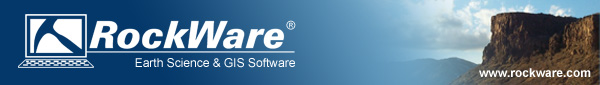
* Display hydrochemistry data in Piper, Stiff, Durov plots, create Stiff diagram maps.
* Create stereonets, rose diagrams.
* Create statistical diagrams - ternary plots, frequency histograms.
* Filter models and compute volumes.
* and much more.
Read more
RockWorks Utilities pricing
DeltaGraph
 DeltaGraph
lets you tell your story with the perfect chart for
your data. DeltaGraph goes beyond the
limits of everyday graphing software with an
unrivaled selection of chart types and unprecedented
formatting flexibility. DeltaGraph
lets you tell your story with the perfect chart for
your data. DeltaGraph goes beyond the
limits of everyday graphing software with an
unrivaled selection of chart types and unprecedented
formatting flexibility.
* Analyze your data with Delta Graph's Formula
Builder and 50 mathematical and statistical functions. Or, fit a curve to your data with advanced regression tools.
* Visualize your results the way you want with Delta
Graph. With over 80 different chart types and 200
different styles, both 2-D and 3-D, you have a
choice of business and technical charts.
* Available for Windows and Mac
Read more
DeltaGraph pricing Back to top
Specials
AqQA and AquaChem Users!
Upgrade to GWB
Essentials for only $499!
 With
the new Geochemist’s SpreadsheetTM in
version 8 of The Geochemist’s Workbench,
water scientists no longer need to use multiple
software applications to work with their data.
GWB can do it all! With
the new Geochemist’s SpreadsheetTM in
version 8 of The Geochemist’s Workbench,
water scientists no longer need to use multiple
software applications to work with their data.
GWB can do it all!
* Store numerous analyses in a single spreadsheet
* Convert units with a click
* Create cross plots, series and time series graphs
* Create water chemistry diagrams: Piper, Stiff, Durov, Schoeller, ternary…
* Compare replicates, check standards
* Check against regulatory limits
* Quick fluid mixing
* Sort by name or value
* Easy speciation, mineral saturation and fugacity calculations
* Overlay scatter data on Eh-pH and activity
diagrams
* Launch other GWB modules for advanced modeling
For a limited time, you can upgrade from AqQA or
AquaChem to GWB Essentials for only $499.
Read more
GWB Essentials pricing
Groundwater Diver
Dataloggers
 Special
Pricing through August 31, 2009 on the following
packages. Special
Pricing through August 31, 2009 on the following
packages.
(DISCOUNT PRICING IS FOR DIVER
QUANTITIES 10, 20, 50, AND 100)
Network Monitoring Pack – Geared for use
in municipalities, landfills, and mining to meet
government requirements. Contact RockWare for more information
and equipment options.
Package includes: Mini-Diver, 30m DDC, Baro-Diver,
1m DDC, PC Interface, DO/DP, Reading Unit,
Diver-Mate, and Diver-Rugged.
Pumping and Slug Test Monitoring Pack -
For use in aquifer performance tests, small diameter
installations, and long-term monitoring.
Package includes: Micro-Diver, 30m DDC, Baro-Diver,
1m DDC, PC Interface, DO/DP, Reading Unit,
Diver-Rugged Reader, and Diver-Mate.
Corrosion Free Monitoring Pack – To be
used for landfills, mining, saltwater installations,
and industrial monitoring.
Package includes: Cera-Diver, 30m DDC, Baro-Diver,
1m DDC, PC Interface, DO/DP, Reading Unit, Diver
Rugged Reader, Diver-Mate.
Read
more
Request a Quote
Back to top
TIPS
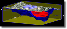
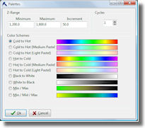
RockWorks14: Color Options for Grids and Solid
Models
Use "Color Fill" tables in Rockworks14 to create
informative (& beautiful!) diagrams, in both 2D &
3D.
Use the Project Manager / Misc Tables to open the
Color Fill table. The Palettes button lets you
quickly create a gradational color scheme for
specific intervals across a value range.
Or, create your own list of any intervals and apply
any colors. One user recently used this method to
display 3D slices of a geophysical model,
highlighting shallow, low-value layers in pastel
colors (g = 0 to 1500) and deep, high-value layers in
bright colors (g = 20,000 to 50,000).
Read more
RockWorks pricing |