New Versions
Hydro GeoAnalyst 2011
Groundwater and borehole data management and visualization
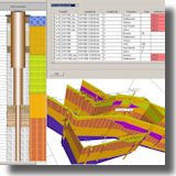 Hydro GeoAnalyst 2011
is your groundwater project solution:
> Flexible: Design the data structure, borehole log templates, reporting styles YOU want.
> Scalable: Expand the scope, size, and structure of your database.
> Expandable: Integrate your Hydro GeoAnalyst project with AquiferTest Pro and AquaChem.
New in Hydro GeoAnalyst 2011:
> Use the new chemical data import wizard to import chemical lab data all in one easy step.
> Quickly assess the quality of your lab data by analyzing sample duplicates, spikes, blanks, dilution factors, maximum detection limits and holding times.
> HGA now automatically flags all chemical data that does not meet user-defined quality checks.
> The Dunham Carbonate Classification and Shell Standard soil classifications are now available with the Environmental database templates.
Read more
Hydro GeoAnalyst pricing
Download demo
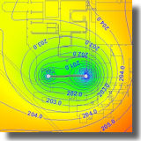
Groundwater Vistas v6
A graphical user interface for groundwater flow & contaminant transport modeling
 Groundwater Vistas is a state of the art software package for 3D groundwater flow and contaminant transport modeling, calibration and optimization using the MODFLOW suite of codes.
What's new in Groundwater Vistas v6:
> Native 64‐bit Version of Groundwater Vistas & all models (not available in Std version)
> Significant interface improvements
> Support for the latest versions of MODFLOW 2000, 2005 and NWT, MODPATH, MT3DS, MODFLOW-Surfact and PEST
> Support for many new MODFLOW packages, including CFP (Conduit Flow Process), SWI (Sea Water Intrusion), MNW2 and the SAMG Solver for MODFLOW2000 and MODFLOW2005
> Enhanced support for PEST Version 12.1 with BEOPEST
Sign up for the upcoming WEBINAR: Calibrating Groundwater Models with Groundwater Vistas and PEST. There will be six lectures over six days in May, with exercises you can do at your own pace. (More.)
Read more
Groundwater Vistas pricing
Download demo
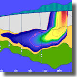
AquiferWin32/Winflow v4
The ultimate in pumping test analysis and simulation
 Aquiferwin32 is a sophisticated Windows program that supports the analysis of aquifer tests, slug tests, and step tests. Multiple observation wells can be analyzed individually or as a group. What's new in AquiferWin32 v4:
New analyses
> WinFlow/Tran is now automatically included in all licenses of AquiferWin32
> Split Version 2.3 – Analytic element flow model developed by Igor Jankovic supporting single layer groundwater flow in heterogeneous aquifers
New functionality
> A new layout view in which headers and footers can be viewed and manipulated on screen
> Multiple map overlays
> Analytic elements checked at calculation time
> Additional annotations including polylines, polygons and a north arrow
> And more
Read more
AquiferWin32 pricing
Download demo
New Updates
PetraSim 5

April 5, 2011: PetraSim 5.1.1605: Fixes two issues related to the new flux-based boundary condition specification options.
March 24, 2011: PetraSim 5.1.1416: Adds the capability to specify surface injection and production (source/sink) using flux. The specified flux is multiplied by the projected area on the XY plane to calculate flow.
Download demo/update
Sale Pricing
Visual MODFLOW
10% Discount until April 30, 2011
 Visual MODFLOW is the proven standard for professional 3D groundwater flow and contaminant transport modeling software.
Through the month of April 2011, all Visual MODFLOW licenses (new purchases & upgrades) and maintenance will be offered at 10% discount.
Read more:
Visual MODFLOW Std, Visual MODFLOW Pro,
Visual MODFLOW Premium
New Pricing
LP360
Price reduction for this popular LIDAR extension for ArcView
 LP360 is a first-of-its-kind LIDAR extension for ArcView. The LP360 LIDAR extension uses a specially-designed ArcMap data layer to draw points directly from LAS files so that you can integrate your LIDAR data with the rest of your GIS, including vector data, rasters, and imagery.
Prices have been reduced on all license types -
Save $241 on LP360 single licenses
Save $76 on LP360 Classify single licenses
and more.
Read more
LP360 pricing
Download demo
Tips
RockWorks15: Create Bubble Maps of Location Fields
 Use the View | Optional Fields command to add new fields to your project's Location table, for input/import of numeric data, such as a temperature or production measurement for the hole. Then use the new Bubble Map layer in the Map | Borehole Locations | Borehole Symbol & Label Options window to create a map with circles scaled to the values stored in that field. You can also grid and contour these data using the new Map | Optional Fields program.
(For row-and-column data in the RockWorks Utilities, use the Map | EZ Map | Symbol Options | Circles to create a bubble map.)
Download demo
|